
Flying the flag atop Pierre de la Lune.
"The mountains are calling and I must go" - John Muir.
We'd been saving the two southern (French) Jura peaks of Pierre de la Lune and les Avalanches for some time, as I'd figured they'd needed a nice, long, fine, mid-summer, sunny day ... and Sunday 27 July 2014 seemed like just the day. (Well at least it looked like that when we set-out from our home in St George.)
The sun was certainly shining brightly as we drove down towards the small French village of Feigères, which is nestled into the forest at the foot of the Jura escarpment just west of Geneva. With the sun shining, and the blue skies promising a perfect day, it seemed like ideal conditions for a hike, for views of the Alps, and maybe even a classic "Mer de Nuage" over Lac Leman. As it turned-out, we didn't get any of the above once we'd reached our destination at the top of the Jura's highest ridgeline.
We shouldered our day-packs, and left Feigères (667m) at about 9.30am, heading northwest out of town along the Chemin des Bocagnes. There are a couple of marked hiking routes leading out of the village, and we opted for the most northerly. It started-out as a two-wheel dirt track, which soon gave way to a leafy trail marked "Sentier des Chezerans" on the topographic map. The "Sentier" was once a major trans-Jura route between Feigères and Chezery-Forens, crossing over the ridgetop at the "Passage de Gralet".

Heading out of Feigères along Chemin des Bocagnes.
The trail was marked with the usual red, and red-and-white striped trail markers - painted occasionally on trees or rocks alongside the trail. Even so, we managed to lose the trail a couple of times, but stayed pretty much on course thanks to our trusty GPS. After a bit of "bush-bashing" we got onto the trail proper, and began the steady ascent up the escarpment - heading first northwest, and then west towards the ridgeline.

Alpine trail marker emblazoned on a beech tree.

The trail through the forest just above Feigères.
The trail, which snaked through the predominantly beech forest, made for fabulous walking, being covered with leaf litter, and shaded from the hot mid-summer sun that shone in the blue skies above. However, it was by no means a "walk in the park" - as it more or less headed straight-up the steep slope - gaining 800 metres (vertical) in altitude in about 2.5 kilometres of horizontal distance - a gradient of about one-in-three. Needless to say, it had us puffing and perspiring, but still enjoying every step of the way. Along the way, we crossed over two forest roads - the most pronounced of which was just northeast of la Grand Combe (1055m).

The forest road at 1055m.
At this point, we entered the Reserve Naturelle de la Haute Chaine du Jura - marked, as usual, by its familiar information panel outlining how best to protect this beautiful natural jewel. We stopped for awhile at the sign to catch our breath, and take a couple of photos, and then pressed-on for the second half of the ascent.

Trail sign at the entrance to the Haute Chaine du Jura natrure reserve.
At around 1300 metres, the trail steepened (the contours on our topographic map almost fused into a solid brown line), and the one-step-along, one-step-up, mountain track had us appreciating our hiking poles like never before. Fortunately it was a gorgeous trail, so we hardly gave a thought to the steepness as we forged our way up the last kilometre or so of the mountainside. For some reason, both on our topo map and in the real world, the trail more or less petered-out - about two-or-three hundreds metres from the ridgeline, so we had to follow our noses - staying on the westerly compass-bearing - and keeping uphill towards the horizon.
Just short of the "Passage du Gralet", the terrain flattened-out and we emerged from the forest into a bushy patch of alpine pasture. It was thick with shrubs, grasses and all manner of herbaceous growth, that shed its collected rain and dew onto our boots and ankles.

Heading-up the Passage du Gralet.
We soon reached the top of the ridge - the Balcon de Lac Leman - and found the familiar walking trail that runs along the top of this main Jura ridgeline - the Chemin de la Crêtes du Jura. At that point, we turned right, to the north-northeast and headed towards our first destination - the summit of Pierre de la Lune. Behind us was le Gralet mountain refuge (1430m), and the two un-named peaks (1461m and 1474m) just above. Le Gralet has been a landmark in this part of the Jura since the Middle Ages, renown as a mountain alpage with a reputation for quality on-site cheese-making.

The le Gralet refuge just above the Passage du Gralet,
and its adjacent un-named peaks.
and its adjacent un-named peaks.
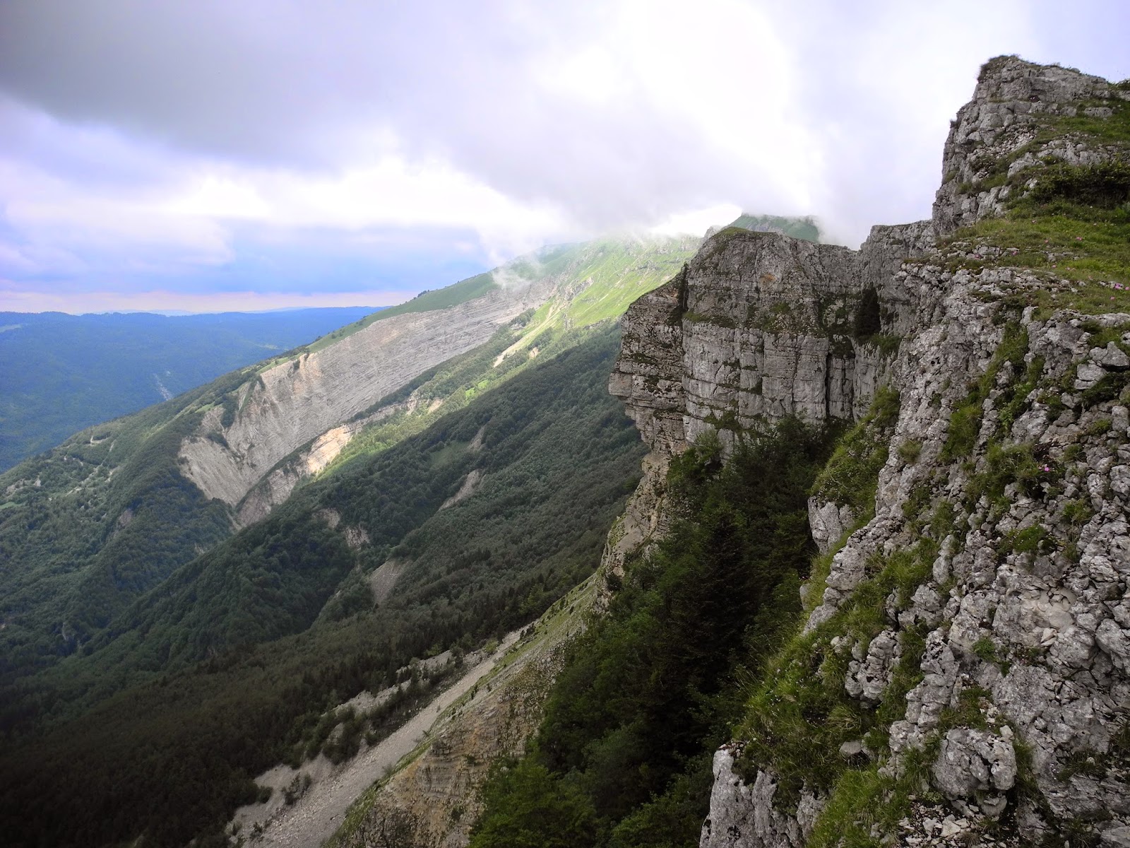
The weather at the top was a world away from the sunny conditions we'd enjoyed as we left Feigères. Now, the skies were clouded over, with just the occasional gap allowing the mountaintop to be lit-up by a burst of sunlight. As it so often does, the Jura was making its own weather, with a bank of cloud streaming-up from the escarpment and enveloping the mountain-top, even though we could see the surrounding valleys and the Geneva plain below us bathed in sunlight.
We headed north along the crest trail and - at about 11:30am - reached the first of the two twin-summits of Pierre de la Lune, at 1505 metres. We had great views to the south - towards the Grand Crêt d'Eau; to the west - into the Vallée de Valserine and across to the second Jura ridgeline; and to the north - towards the Jura's highest peaks, with Le Grotte de la Marie du Jura (aka la Marie du Jura and Crêt de la Grotte), Roche Franche and le Reculet standing-out on the horizon before us. With ominous clouds screaming-up the mountainside and "whiting-out" the landscape near le Reculet, we hastily took a few photos of the gorgeous views all around us.

Looking south towards Grand Crêt d'Eau from Pierre de la Lune.

The view down the Vallée de Valserine over Mentières and far beyond.
We dropped our packs, changed into dry shirts, and pulled-on windbreakers against the chilling wind that cut through the wintery air on top of the ridge. With a wall of cloud continuously surging up the slope, dissipating, and re-forming on the eastern side of the ridgeline, we sat down and faced to the west - soaking-up the beautiful views over the Valserine around the village of Chézery-Forens, and the mountain-tops around Crêt de Chalam - which we'd climbed on a memorable hike (in near-Arctic conditions) last winter.

Our amazing picnic site on the Jura crest - with Le Grotte de la Marie du Jura,
Roche Franche and le Reculet emerging from the wall-of-cloud in the background.

Lunch-time view towards the Crêt de Chalam.

Looking north at the Grotte de la Marie du Jura,
and (in shadows in the mid-ground) the summit of les Avalanches.

Sunshine fills the huge, rocky gouged hollow of Roche Franche.
We had a fabulous lunch, soaking-up the views and the occasional ray of sunshine that broke through the scudding clouds above and around us.
At around 12:30 we packed-up and headed a little further north along the ridge to the second summit of Pierre de la Lune (1506 metres) - where (as has become our custom), we had a nip from our hip-flask of French marc, and took a ceremonial "flying-the-flag" photo to commemorate the occasion. Pierre de la Lune, in the Rhône-Alpes gets its name from the distinctive white calcareous limestone rock of the Jura. Its name literally means "the stone of the moon", or "moonstone".

At the top of Pierre de la Lune (1506m).
Sufficiently wind-chilled, we headed further north along the ridge towards our second summit of the day - les Avalanches. It was just a few hundred metres ahead of us, although it frequently disappeared from our view as we were sequentially shrouded in cloud, then bathed in sunshine, then plunged back into cloud again.

Walking into a white-out upon leaving la Pierre de la Lune.

Approaching les Avalanches, with Roche Franche in the far distance.
With a beautiful, easy trail before us, it didn't take long to reach the top of les Avalanches (1497m) with its imposing, towering cliff faces and rubble-strewn scree slope far below. Once again, we dropped our packs to wander around the summit and enjoy the views, before taking more celebratory photos to record being on the 60th Jura peak that we'd stood atop since beginning this little Jura Mountain Rambling project two years ago. (Pierre de la Lune and les Avalanches are actually ranked numbers 43 and 44 respectively on our list of highest named Jura peaks).
The summit of les Avalanches (at right) with Roche Franche in the distance.

Enjoying the views north from les Avalanches.

Roche Franche and La Grotte from les Avalanches.

Standing atop les Avalanches (1497m).
After soaking-up the amazing views to our heart's content, we dropped-down the north side of the peak to begin our return journey back to Feigères. The trail hugged the cliff-tops, so we stopped from time-to-time to turn around and check-out the rugged landscape one last time before we had to leave the crest and head downhill.

Looking back at the western cliffs of les Avalanches.
Standing on top of this highest Jura ridgeline - that disappeared into the distance to the southwest in one direction, and to the northeast in the other - and then seeing the same, near-impenetrable barrier replicated by the second ridgeline to our west, it wasn't hard to see why the long Valserine Vallée that stretched-out between the two ridgelines had been of such strategic importance to commerce and trade, and transit and defence in centuries past. Once called "the Spanish Road" - as it had actually been under the control of the King of Spain in the 16th century, linking lands he controlled in Franche-Comté to others in Italy - it was frequently filled with columns of Spanish soldiers marching up and down the valley. At different times it has been of great strategic importance to the Kings of France, the French resistance (during WW2), columns of Roman legionnaires (following Caesar into Gaul), and, more recently, tradesmen, farmers and foresters with their fare of cheese, grapes and wine, clocks and timber.

A last glimpse into the Vallée de Valserine below Crêt de Chalam (far right).
Only a couple of hundred metres beyond les Avalanches, we left the ridge trail and (turning right, cross-country) headed east down the mountainside - towards an alpine farmhouse called "la Capitaine". A trail didn't really exist until we'd reached the farmhouse, beyond which we (at first) followed a two-wheeled forest track that led down towards Tiocan (the start-off point for hiking to the top of le Reculet and Crêt de la Neige).

Heading down the forest trail from la Capitaine.
After a couple of zigs and zags, we left the road and picked-up a walking trail (marked "les Bas Monts" on the topo map) that headed southest down through the forest towards the village of St-Jean-de-Gonville (the nearest village to the north of Feigères). Like the trail we'd taken up the mountain earlier in the day, this was a gorgeous, leaf-littered, shady trail through the forest, past fallen logs, rocky outcrops, mossy groves and all manner of enchanted nooks and crannies.
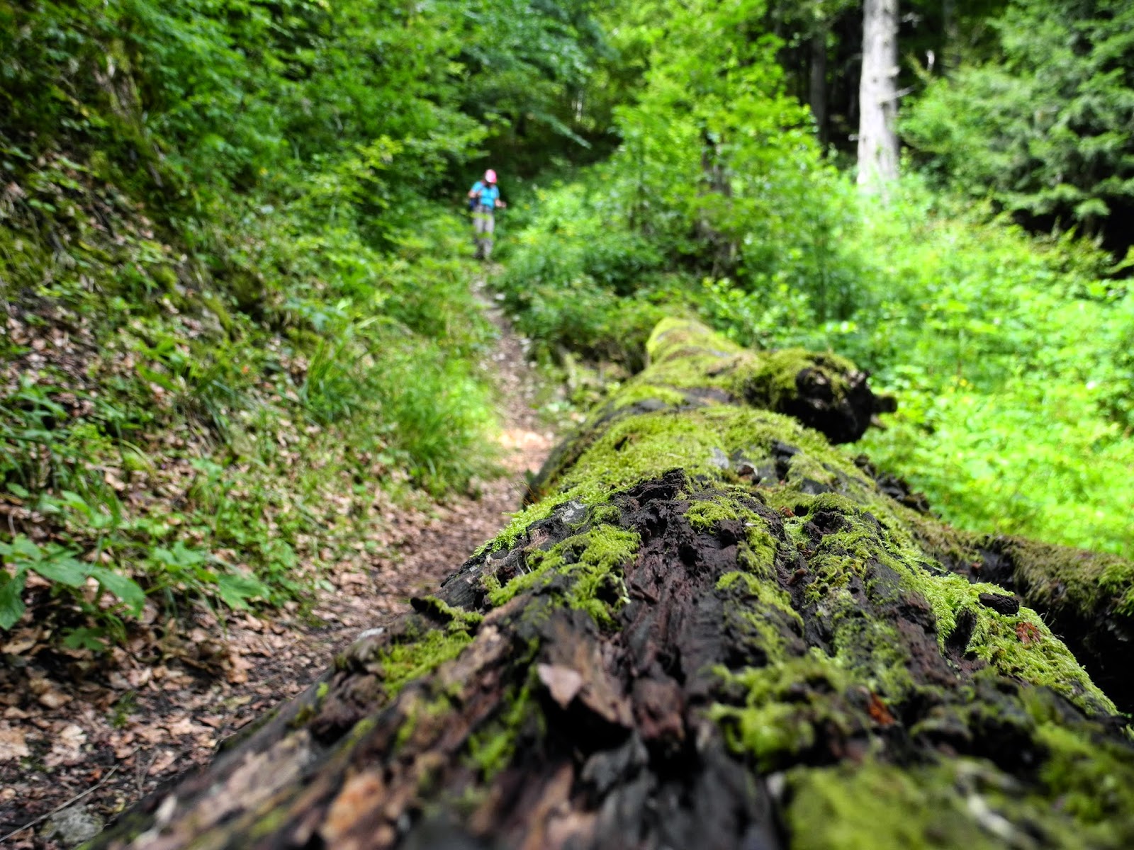
A moss-covered fallen log on les Bas Monts walking trail.
We followed this trail until it intersected the highest of the two forest roads that we'd cut across on our way up the mountainside earlier in the day. We turned right (southwest) onto the road, and followed it until we reached our morning walking trail - the Sentier des Chèzerans at a waypoint marked 1055m on the map.
There, we turned left onto the track and headed east, then southeast, down through the leafy beech forest. Once again, the trail was just lovely, and a hell of a lot easier than what it had been on the way up in the morning.

The Sentier des Chezerans through the forest above Feigères.
Less than two hours after we'd left the summit (at about 3pm), we arrived back in Feigères - about five and a half hours from when we'd set-out that morning. Although we'd got none of the weather we'd been expecting, or none of the views we'd been hoping for (over Geneva towards Mont Blanc and the Alps), it had been a magnificent hike. As mentioned earlier, les Avalanches was our 60th Jura peak - a milestone which we though would be worth celebrating as we climbed into our car and began thinking about getting in to a hot bath, with glass of red wine, once we were back at our home in St George. Life doesn't get much better than that.
Jura peaks bagged:
- Pierre de la Lune (No. 43) 1506m
- Les Avalanches (No. 44) 1497m
I wonder what's the point of the Swiss flags (you are in France after all, if it's a joke, it's in bad taste).
ReplyDeleteHi Sigognac, Thanks for asking. No, it's not a joke and not meant to offend by any means. I made a commitment (while I was living in the Swiss Jura) to climb all of the highest peaks in the Jura. Just after I started, I found this flag lying on the ground at one of the summits, and then decided to hold it up once I'd got to the top of every peak. It was just my way of marking that I'd reached the summit. Best wishes, Richard (now back home in Australia)
Delete