
Le Dent du Chat and Molard Noir summits.
Molard Noir and Dent du Chat are the two highest named peaks on the imposing Mont du Chat massif - an anticlinal which forms the southern-most tip of the entire Jura Mountain range. (It's also a part of the Rhône Alps region of the French Savoie). The highest point on the range is actually higher than both of these peaks - but this (at 1504 metres), is ignominiously merely called "le signal du Mont du Chat" ... and has a road constructed right over the very top of the hill which, not surprisingly, is "adorned" with a monstrous communications tower - "le signal".
Le Dent du Chat and, to a lesser extent, Molard Noir, are much harder to get to, require more climbing and are far more beautiful, so I've chosen to make them the real destination, representative summits of the Mont. Certainly, le Dent du Chat, with its distinctive jagged rocky pinnacle - composed of ancient Kimmeridgian (Jurassic) limestone reef - must be one of the most spectacular (and popular) hiking destinations in the entire French Jura. It was definitely a busy mountain-top the day we were there (on Saturday 2 August 2014).
The Mont du Chat is about two hours drive south of Geneva - dominating the landscape on the western shores of the beautiful Lac de Bourget. We drove south to Chambéry, then around the southern arc of the lake to a small village called Bordeau, from where we snaked our way (about four kilometres further on) up the mountainside to the Col du Chat (638m). The col is the most popular starting point for hikers heading for either Dent du Chat or Molard Noir. It requires about 800 metres altitude gain, compared to other potential starting points: Bourdeau (approx +1000m), the Relais du Mont du Chat (+100m) or la Fontaine des Côtes (+400m).

The winding road - zig-zagging its way up to le col du Chat from Bordeau.

Looking back across le Hameau du Col du Chat and Lac de Bourget
towards Aix les Bains and the foothills of the Alps.
towards Aix les Bains and the foothills of the Alps.
We parked the car in the big car-park at the col, and wandered around for awhile to read all of the interpretation signs and get our bearings - before shouldering our packs and heading south onto the trail. The "Tour de la Dent du Chat" must be one of the best signposted walks in the Jura, as there were plenty of signs and markers - all the way along the trail. It would have been near impossible for anyone to get lost!

The starting point at the col du Chat (638m) - a popular destination for cylists.
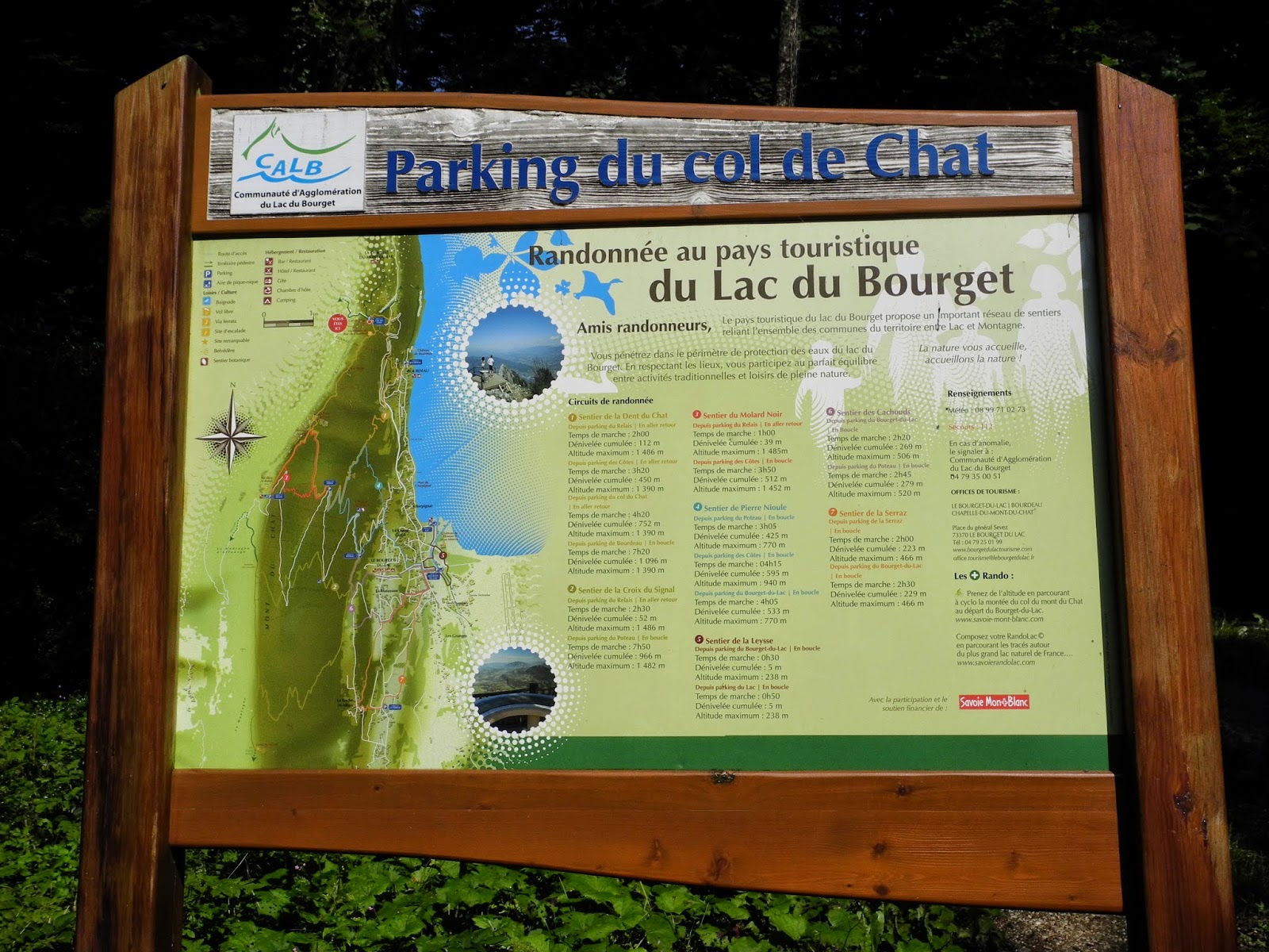
Interpretation panel at the col du Chat car-park.
The trail to the Dent du Chat is mostly through beautiful alpine forest, but it does have some sections that require scrambling over rocks, skirting cliffs and ravines, and making use of ladders and fixed cables. It is also very exposed at the summit itself. As a result, there are plenty of warning signs - particularly addressed to the unfit or unprepared, or those who might suffer from vertigo. The signs recommend that hikers are well-kitted and well-prepared, stick to the marked trails, and avoid bad weather.

Safety warning sign near the start of the walk.
The entire mountain range - the Massif de l'Epine-Mont de Chat - is heavily forested, with many crags, caves and grottos. Not surprisingly, it is also a great refuge for local alpine fauna. Chamois have recolonized the massif (since 1986), but wild boar and deer also inhabit the range. We didn't see any of these during our walk, although we did come across chamois tracks and dung among the rocks near the summit of Dent du Chat.

Fauna interpretation panel - on the trail just after leaving the col du Chat.
Sufficiently informed, we started our walk at about 10:30am, and, being in no rush (as it's not a very long hike), sauntered-off along the well-formed path that headed south into the (predominantly) beech forest - le forêt de Cornillon. It was a lovely sunny summer morning, and we were in high spirits - "in the mood" if you like - for a great hike. The trail is officially called "le Sentier de la Dent du Chat", and forms part of a longer walk called "le Tour de la Dent du Chat".

The first section of the trail leading south away from the col du Chat.

The route is well marked - with yellow; yellow-and-white; green-and-white,
and red-and-white markers on different sections along the way.
and red-and-white markers on different sections along the way.
After about 15 minutes we reached - and passed - a popular via ferrata site , and we could hear the excited squeals of some people negotiating the exposed cliffs of Roc de Cornillon above us. We stopped for a moment to watch a couple of climbers inching their way across a cliff-face (and wished that we'd brought our own via ferrata gear with us), and then headed on our way - the trail now swinging around to the southwest.

Sign at Forêt Cornillon - or Bois du Cornillon (822m).
We slowly worked our way up the massif on a gorgeous leaf-litter-covered trail and, although the sun was shining happily above us, we were cool and comfortable in the shade of the forest canopy just about all of the way. There are a couple of steep slopes and switchbacks to negotiate, but these are easily managed - thanks to the well established zig-zag path up the slopes. It sure was a lovely trail. (Somewhere way underground - deep below where we were walking - is a road tunnel that cuts through the heart of the massif - the Tunnel du Chat - which was opened in 1932).

Heading-up one of the zig-zag sections.
About an hour into the walk, we arrived at Le Roc Blanc (which was easily reached with a slight (100 metre), detour to the east. It was well worth the extra effort - as it wasn't far, and gave us our first views of summit of le Dent du Chat up ahead, as well as views out over Lac de Bourget and far beyond. There are meant to be superb panoramic views of the lake and Alps, but the latter were obscured by clouds, so there were no such sights for us on this walk.

Trail sign near le Roc Blanc (1012m).

A glimpse through the trees of the rocky summit of le Dent du Chat.

The steep western side of le Mont du Chat, with the rocky crag
of le Dent du Chat at the top of the massif.
of le Dent du Chat at the top of the massif.

If you look hard, you can see two figures standing on the top of le Dent du Chat.
The views were beautiful from Le Roc Blanc ... although a little bit disturbing - because we could see thin wispy clouds starting to gather around the top of the mountain - occasionally "whiting-out" the rocky Dent. This spurred us into action and back onto the trail, and we were soon skipping along the leafy, relatively flat section immediately south of le Roc Blanc.
Our next landmark was the Col de la Vacherie (1068m) - which we reached at about mid-day (the trail sign said 1 hour 25 minutes back to Le Col du Chat). The col is the intersection of two trails - the Sentier de la Dent du Chat (which runs north-south along the ridgeline), and the Sentier des 4 Chemins (which, at this point, heads west - down the escarpment to the village of Vernatel). Down there somewhere in the forest are "la Grande Vacherin Ruines" (whatever they were), while off to the eastern side the most significant landmark was the Grotte Parin ... and lots of vertical cliffs which showed-up as dark black gouges across our map.

Trail sign at Col de la Vacherie (1068m).
The next section of the trail, still going steadily uphill, was an absolute delight - with lots of switchbacks, narrow ledges, rocky ridges and other obstacles (fallen trees and branches; roots and rocks). It certainly wasn't a "cake-walk" and one had to keep an eye on where your were putting your feet. One slip in a few places could have spoiled a damn fine hike. Fortunately, we made no false moves, and instead enjoyed one of the best sections of any hike we've ever done anywhere in the entire Jura.

Lis on a lovely easy traverse section of the trail just southwest of le Roc Blanc.

Heading up a slope south of le Col de la Vacherie.

A beautiful ridgetop section of the trail.
The northern approach to le Dent du Chat was closed - due to the dangerous conditions in the steep, rocky chute that leads up to the summit - so we followed the trail that skirted around the western side of the peak, leading to a second route to the top - which approached the peak from the south.

Trail sign at the (closed) northern route to the summit of Le Dent du Chat.
The "bypass" trail around the western side of the peak was also not for the faint-hearted, nor anyone who suffers from vertigo. It required negotiating one particular section where the ground fell away sharply into a deep ravine below ... and one had to hang-on to the fixed steel cables and use steel footholds drilled into the cliff-face to make progress. It sure was fun going. And there's nothing like a bit of adventure to spice-up the day!

Heading onto the tricky section of trail below the summit of le Dent du Chat.

The trail cutting under the Dent du Chat rockface.

Cliffs, rockfall scree, slippery slopes ... and a coming white-out. Oh great!
Perhaps of most concern to us as we passed through this section of the trail was that, in emerging from the forest and scrambling across this rocky, exposed side of the mountain, we realized that the clouds that we'd seen forming when we were at Le Roc Blanc were now all around us, and the visibility was diminishing with every step-up in altitude.
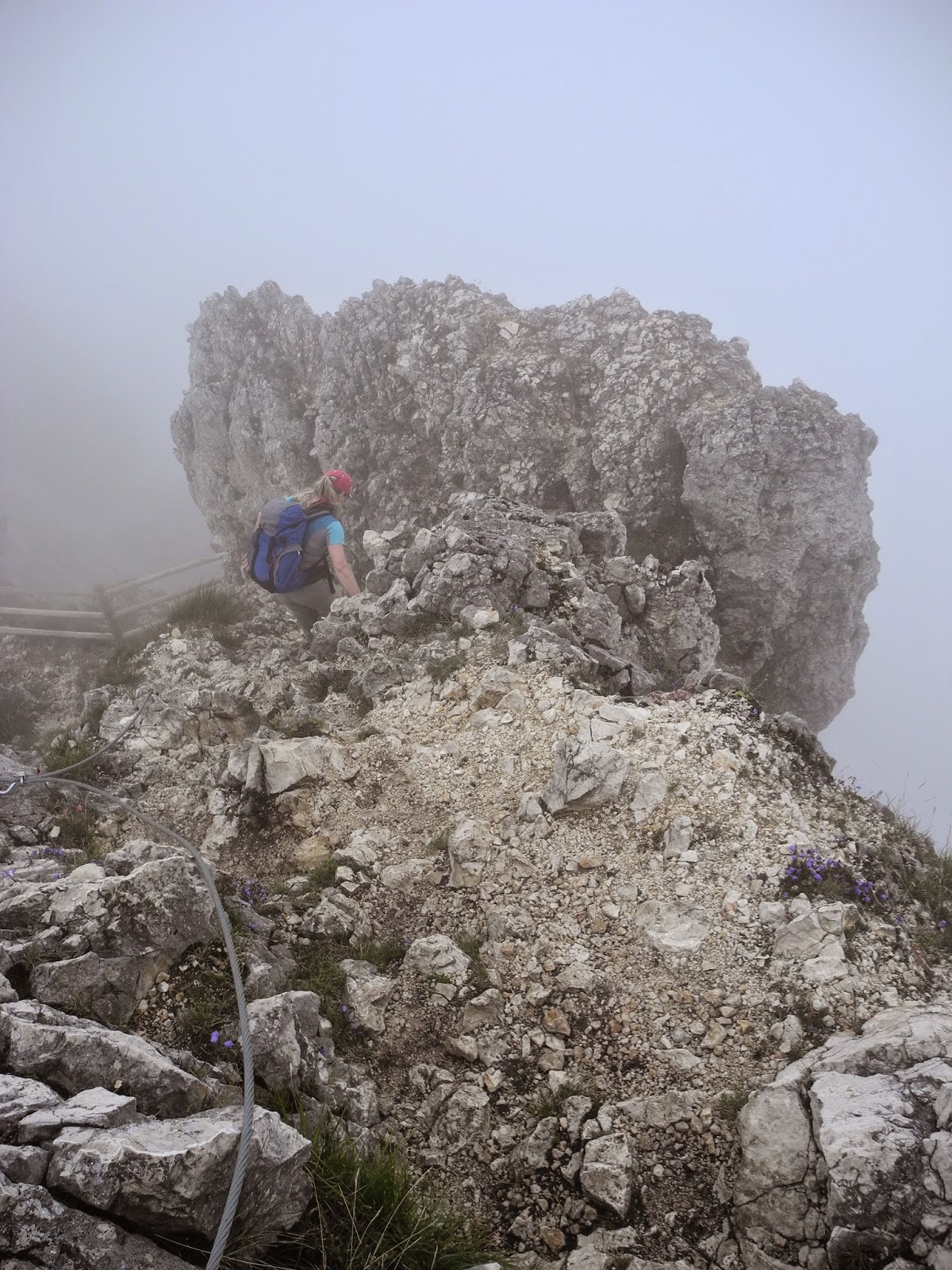
The sun had completely disappeared from the skies above us by the time we plunged back into the forest south of the peak, where we reached another junction in the Sentier des 4 Chemins trail (this one heading southeast down the mountainside towards le Fontaine des Côtes - and eventually by a circuitous route, back to le Col du Chat by a lower road heading back to the north). We turned back to the north, and scrambled up the rocky approach to le Dent. It was just 10 minutes away, but easily the most treacherous section that hikers have to face anywhere on the route.

Trail sign at the southern junction of Sentier des 4 Chemins (1320m).
Once again there were "Danger" warning signs recommending a safe and cautious approach for this final section, as well as when you are on the top of the mountain - as the summit area is small, with no barriers to stop one from falling off the mountain. There is also a risk of falling rocks, possibly dislodged by climbers above you. Needless to say, we took it easy, especially as we were now becoming completely enveloped in one of those typical, misty Jura Mountain white-outs. Fortunately, there were fixed ladders and steel cables wherever the going got really tricky, so we were soon scrambling up to the summit.

Warning sign near the southern approach to the summit of le Dent du Chat.

A memorial plaque fixed to the cliffs just below le Dent du Chat summit.

A series of three fixed ladders heading-up the southern chute.

Lis approaching the top of le Dent du Chat.
Shrouded in a thickening layer of surrounding cloud, we finally emerged at the top of the mountain - a narrow flattened terrace adorned with a rough-and-tumble cairn and steep drop-offs all around. Due to the white-out, we couldn't really see how precariously we were perched on the top of the mountain, surrounded by "the great void", but it sure felt eerie. It was about 12.30, and we were both feeling famished. Lis took off her red scarf and dared me to make a bull charge ... but I passed on that fantastic opportunity, and instead, we settled down on the rocks to eat our lunch, hoping the clouds would lift and give us some of those famous Dent du Chat views.
The Dent du Chat gets its name from its toothy profile ... and some rather interesting folklore. Obviously the "Dent" part refers to the tooth-shaped, rocky summit (originating from the Latin word dens, dentis meaning "tooth"), but the "Chat" part is far more intriguing.
Local legend has it that many, many years ago a local fisherman (called Antoine) was plagued by bad luck, and hadn't caught anything for days on end. In desperation, he appealed to the devil for help, vowing to release the first fish if he could catch one. The devil appeared and said that he'd help Antoine to catch some fish - on that condition: that he threw the first one he caught back into the water. Unfortunately the first fish was one of the best he'd ever caught, so Antoine (in breaking his promise) decided that the devil wouldn't mind if he threw-back the second one instead. More unfortunately, the second fish was even bigger than the first, which prompted the devil to make an appearance to remind Antoine of their agreement ... but he kept that one too. The same story applied to the third fish that he managed to catch. The fourth catch that Antoine hauled out of the water turned-out not to be a fish, but a kitten. Surprised and confounded, Antoine decided to pack-up his gear and head home, taking the three big fish, and (in his pocket) the kitten, which he though would be handy around the house for catching mice and rats. Back home, the kitten grew quickly into a sizable cat, and then continued to grow into a veritable giant, and began devouring everything living being around - including Antoine and many unwary travellers who tried to pass over, or near, the Mont du Chat - an excellent advantage point where the cat had taken-up residence. King Arthur, and two of his companions (Bérius and Mélianus), who happened to be travelling by the way of the Mont one day, then make an appearance in the legend. They were told about the giant cat, and were probably in with a chance of becoming the cat's next prey. So instead they set-up a trap, using a lamb as a bait, and slew (with their bows-and-arrows) the giant cat when it came in to kill the lamb. The cat was then thrown into the lake - except for one of its teeth which was set in to the rocks at the top of the mountain to remind everyone of the bad luck that would come their way from doing deals with the devil. It is said that the curse of the devil, and the giant cat, still remains, and that violent storms will spring-up over the lake, and upturn fishing boats, if anyone who's not keeping their promises ventures onto the water .
Other accounts say that the "chat" has nothing to do with cats, but comes from an ancient Gallic word which had the same root as chat, but means "passage" as in passing through the "eye of the needle". Hmm, who knows for sure? The true original may well be lost in time. What we do know for sure is that it was first called Mont du Chat (in a charter, made in Chambéry) in 1232. Prior to that, the mont had been called mons mons Muniti Munni.

El toreador atop le Dent du Chat.
Alas, we had no such luck with the clouds and the views, so instead I had to jump-up whenever there was a rare break in the clouds, that either filled our eyrie with sunshine, or gave us a glimpse of the views that should have been on show all around us. Normally one can see a fabulous panorama that takes in Lac du Bourget, the Alps (including Mont Blanc), the Bauges and Chartreuse mountain ranges, and the peaks of the Savoyard foothills (l'Avant Pays Savoyard). Unfortunately the views on this occasion were nonexistent, and more like rushed glimpses, but we did get some idea of the majestic loftiness of our location.

A brief glimpse of Molard Noir - our next peak
- through the clouds from Dent du Chat.
- through the clouds from Dent du Chat.

Looking down at the southern end of Lac de Bourget.
As usual, we took a celebratory, "ceremonial" flag-waving photo near the rough-and-ready cairn, and soaked-up the atmosphere of standing on top of one of the Jura's most distinctive, characteristic and popular peaks. And then we packed-up our kit, and headed down the crag towards our next destination - the nearby summit of Molard Noir.

Waving the flag atop le Dent du Chat (1390m)
Heading back down from the summit of Dent du Chat.

The exit trail heading south from the top of Le Dent du Chat.

Lis on the ridgetop trail at le Dent du Chat.
We retraced our steps along the trail back to the Sentier des 4 Chemins, and followed the trail heading southwest towards Molard Noir (20 mins) or the Relais du Mont Chat (50 mins). The latter is a popular starting point for many who walk to Molard Noir and Dent du Chat, but it's a relatively easy walk, mostly along the ridgetop. It's possible to drive all the way to the top of the Mont du Chat, and to park under the huge (ugly) TV relay tower - an option that didn't appear interesting to us. What is interesting (I guess only to some though) is that there's also a memorial stone up there - in honour of a number of service-men who were killed when a military aircraft crashed into the mountain-top in October 1946.

Trail sign at the Sentier des 4 Chemins (1320m) pointing towards Molard Noir.
The track from the Sentier des 4 Chemins junction to Molard Noir was quite steep, with a few slippery and rocky sections that kept our attention. Fortunately there were once again fixed steel cables on some of the more precarious sections, so it was relatively safe and easy going.

The fixed steel cables made the rock scrambling a bit easier.
Twenty minutes later we were standing on top of Molard Noir - 1452 metres, and number 58 on our list of the Jura's highest named peaks. Unfortunately, we were also standing in a complete white-out - which meant that we could see virtually nothing beyond about 30 metres around us.
"Molard" simply means a big hill, or small rounded mountain - and is derived from the Latin word moles which means "mass" or "heap", and the old French word mole - which means "mass" or "molar tooth". "Noir", of course, means black, and probably relates to the dark and shady spruce forests that blanket the Mont and much of the ridgeline.

Signpost near the summit of Molard Noir (1452m)
Molard Noir is well set-up for visitors, with a picnic bench and two viewing platforms, each with very informative and artistic orientation tables. We checked both of them out, and anguished over the wonderful sights that we were missing - hidden beyond the cloudy cloak that had wrapped-up the mountain-top.

There are magnificent views out there ... somewhere.
Looking out from the west-facing viewing platform.
The west-facing viewing platform is precariously perched above a very high, and very vertical cliff-face, so one wouldn't want to step off the platform in that direction. It normally provides fantastic views for miles and miles - out over the rugged, hilly landscape that takes in the Savoy towns of Yenne and St Jean de Chevelu, and the Monts du Lyonnais and the distant mountains of Beaujolais, as well as Lac Paladru and the Rhône valley. We could only see what was on the orientation table ... and wish for the clouds to lift. But alas again. No such luck.
The orientation table was very ornate, with a mountain of information about the surrounding countryside and distant views. The table was erected in 1964 - by le Touring Club de France and le Comité National des Sentiers de Grande Randonée - in collaboration with the Consul General of Switzerland. (The latter gave us better reason to be flying the Swiss flag up here ... which is what we did of course, as usual.) We also took our customary, celebratory (and heart-warming) swig from our hip-flask of French marc.

The west-facing orientation table atop Molard Noir.
From the east-facing viewing platform, we should have had an amazing view of the jagged peak and precarious cliffs of the south face of le Dent du Chat, with Lac du Bourget and the Bauges Mountains behind, but unfortunately everything was completely obliterated behind the clouds. Somewhere, hidden, on the horizon were the Alps - crowned by Mont Blanc and its majestic neighbours.

The east-facing orientation table.

Orientation table detail for the Massif du Mont Blanc section.

Saluting the Swiss Consul General atop Molard Noir (1452m).
Given the cloudy (and quite chilly) conditions, we didn't stay too long at the summit, and were soon on our way back down the mountainside - retracing our route northeast towards the Col du Chat. It's less than a two hour walk back to the col, but we were in no rush - as it's such a gorgeous trail along the Mont du Chat ridgeline. Each of the landmarks along the trail came along surprisingly quickly, and we were soon skipping over the rocks and ridges, ravines and switchbacks that had slowed us down on the way out earlier in the day.

Negotiating the precarious section of trail
just under the western cliffs of Dent du Chat.
just under the western cliffs of Dent du Chat.

The fixed cables certainly made life easier on some of the trickier sections.

Zig-zagging our way down through a section of switchbacks.

Another section with fixed cables.

It's a gorgeous trail, and mostly relatively safe and easy.

Heading back down through the beech forest approaching the Col du Chat.
We arrived back at the Col at about 4pm - approximately five and a half hours from when we'd set-out. (The total distance is about 9 or 10 kilometres, and mostly relatively easy walking.)
It had been a great walk, on a great trail, through a beautiful forest, to three fabulous peaks. It was a shame we didn't get to see any of the amazing views that the summits are famous for ... but it just means we'll have to come back again another day, and do it all again. It's such a beautiful place.

The view from the road west from the Col du Chat - looking back at the west side of the Mont du Chat massif. Dent du Chat and Molard Noir are almost obscured in the clouds on the far right.
Jura peaks bagged:
- Molard Noir (No 58) 1452m
- Dent du Chat (No 88) 1390m
- Le Roc Blanc (No 417) 1012m