A beautiful sunny Saturday morning beckoned a return to the
Jura summits after a hectic past month of travelling around the globe for work
commitments – to the Netherlands, Washington, South Africa, Bangkok and
Beijing. Fortunately, while in China, I did manage to get out of the treadmill
routine – of airports, taxis, hotels and meeting rooms – to at least visit the
incredible Great Wall of China.


That’s quite a statement from a man who was a master of words (often described as “the German-speaking culture’s Shakespeare”, and "the Prince of Poets").


The Great Wall of China, February 2012.
Today we’re back in the land of the “great walls of the
Jura”, like the one below which I photographed on the way up to the summit of La Dôle in
September 2010.
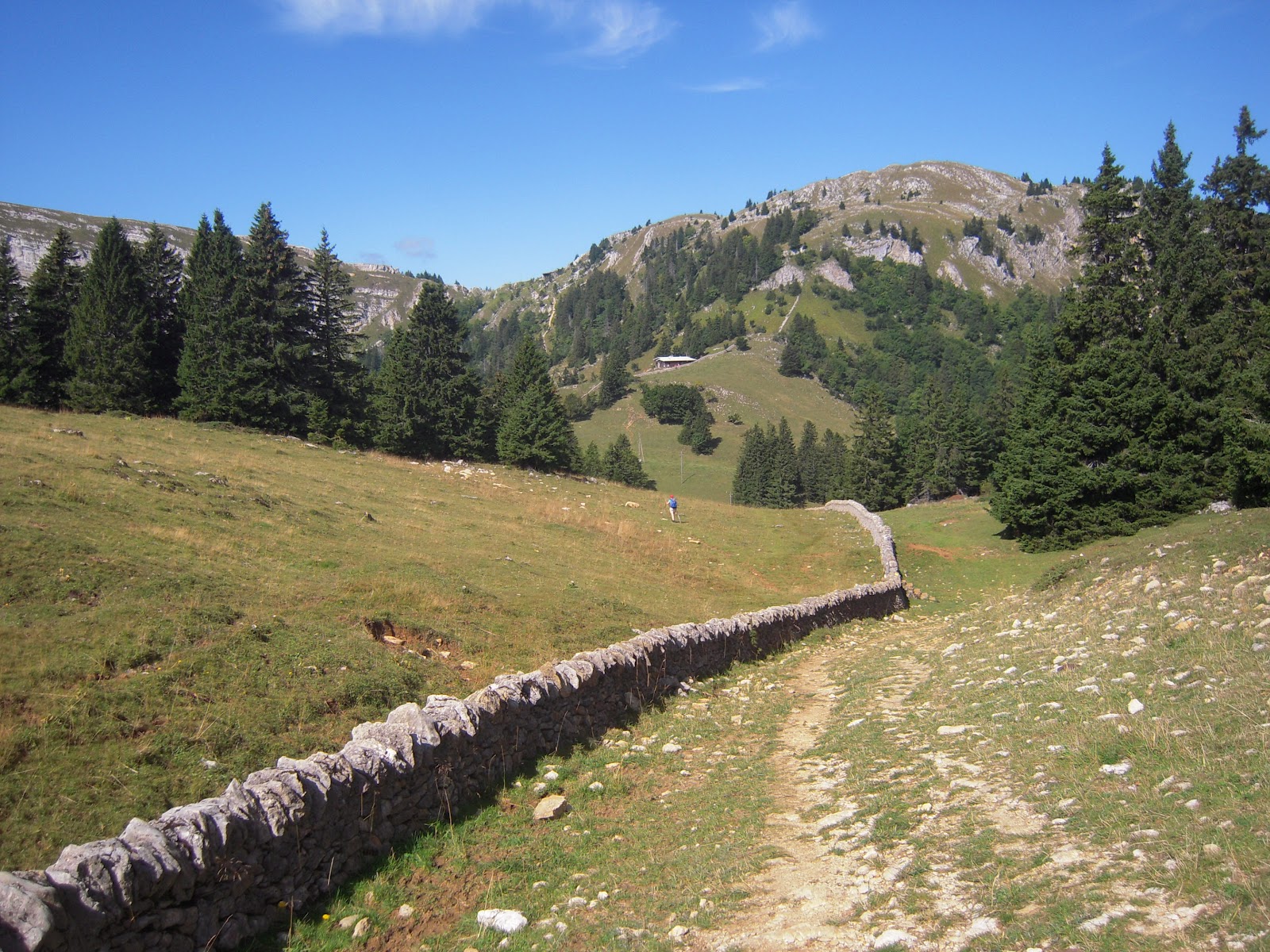
The Jura has hundreds of kilometres of lovely old dry stone walls.
We passed over the same wall on this hike … although it was
buried somewhere beneath deep snow under our snowshoes. Lis and I have been
to the top of La Dôle twice previously – once in mid-winter (in January 2010)
when we got caught in a
near-Arctic white-out and windstorm at the summit that meant we returned with
no photographs, near frostbite, and nothing but memories of hardship and discomfort.
We returned to this beautiful landscape later that year (in September) and had
a wonderful hike to the top of La Dôle again, via La Barillette.

On the summit of La Dôle in September 2010.
We took pretty much
the same route today, leaving St Cergue at about 9.30am. We walked the first
kilometre or so without our snowshoes, because the trail was so well
packed-down by previous walkers. However, we soon passed the extent of most
day-trippers so stopped to pull-on our snowshoes and continue on our way,
higher and higher up the trail through the Jura forest. We took a detour off
the main trail towards La Barillette, which required setting our snowshoes to
their “steep uphill” configuration, which raises your heels by about five
centimetres. Even so, the icy slope was hard going, prompting Lis to quote from “The Thirteen Clocks”
by James Thurber:
“The way is
long. And getting longer.
The road goes uphill all the way, and even farther …
The road goes uphill all the way, and even farther …
“The way is
dark, and getting darker.
The hut is high and even higher.
The hut is high and even higher.
I wish you luck.
There is none.”
Fortunately, luck was
with us and we soon arrived at the front terrace of the “hut” – the Restaurant
de la Barillette where we stopped briefly to take a few photos. "Barillette" is thought to be derived from either the French word baril, and means "a type of little barrel" (in reference to its rounded shape); or from the Celtic word bar or bari which means a height. In the Celtic case, Barillette could therefore be a diminutive of bari, meaning a "little height" (in comparison to the nearby, higher peak - la Dôle).

Lis in front of the Restaurant de la Barillette.
The
views were amazing, with the panorama of the Alps sandwiched between two layers
of cloud. Below us, the lower layer – the “Mer de Nuage” (the “Sea of Cloud”
that frequently covers all of Lac Léman) completely obscured the lake and all
of its surrounding landscape, while the upper layer blocked-out Mont Blanc and
clipped the top off all of the highest peaks on the southern and eastern
horizons.

The "Mer de Nuage" over Lac Léman. Dents du Midi on the left horizon.
Fifteen minutes later
we were at the top of La Barillette – number 38 on the list of highest
peaks in the Jura (1528 metres above sea level). With its magnificent panorama
views it felt like we were on the top of the world, yet it’s only the 6,280th
highest mountain in Switzerland. We stopped there awhile to refuel – with a
handful of fruit and nuts, washed down with warm lemon water – and take a few commemorative
photographs.

This home-made snowplough ain't going nowhere!

Near the summit of La Barillette (1528m)
La Barillette stands-out from the surrounding countryside due to a
huge (120 metre high) FM radio and TV aerial built on its peak. The red and
white striped aerial services the Swiss Broadcasting Commission TSR and RSR networks
– across southwest Switzerland and nearby France.

From La Barillette we
headed cross-country, first following the footsteps of other trekkers, and then cutting our own fresh trail across the snow towards La Dôle.

We eventually cleared the forest at
about 1400 metres – in the combe of the Chalet de la Dôle
– where we stopped
awhile to take-in the whiter-than-white panorama of the valley, picking-out
just the roof-top of the chalet which was buried in snow deep down in the
valley.

Of course our eyes were drawn more to the summit of La Dôle
in the background,
with its radar installations and 230 metre high cliff-face. This imposing rock
face is called the Dôle cirque - a huge anticline, of exposed convex folding strata.


We resumed our
journey, and soon passed-by the Chalet des Apprentis (so-called because it was
built as a project by the apprentices of Geneva between 1964 and 1967), and
headed up the slope … following a faint trail of footprints heading in roughly
the same direction that we were going. Unfortunately the trail turned out to be
a poor choice and we found ourselves way below where we needed to be to make it
to the summit. Strangely, we came across another hiker lying on the trail,
pretty much where it simply petered out. In our rough French we checked that he
was okay (he appeared to just be taking a rest), then I cut new steps up the
slope, zig-zagging back and forth until we eventually got onto a better set of
tracks following a traverse across the mountainside.

Making our way along the precarious traverse towards the Col de Porte.
It was somewhat precarious
in parts, but we eventually made it safely to the Cabane du Ski Club de Nyon
and the adjacent “level” ground on the nearby Col de Porte (1,558m).
From there we edged
our way along the ridgeline, steering well clear of the dodgy-looking
cornices at the top of the cliff-face. We thought we were far enough back from
the edge, and yet still came across one large fissure that prompted setting a
newer course even further away from the avalanche zone.

Lis heading towards the ridgeline.
We arrived at the
summit of La Dôle at
about 1.30 (four hours after we’d left the car-park in St Cergue). There were a
few other snow-shoers up there, and lots of skiers – who’d all come up the easy
way, via the two ski lifts that come up from the French side of the massif: the
Telesiege des Dappes (bring skiers from Les Dappes) and the Couvaloup ski lift.
The latter is located on the north side of La Dôle in the vicinity of “Couvaloup Crans” –
where a bunch of wolves were found dead in caves and crevasses after a huge
storm passed over the mountain in 1960.

At 1677m, La Dôle
is the second highest
mountain in the Swiss Jura (just two metres lower than Mt Tendre), and like its loftier
rival, is a bare windswept summit above the tree line.
The word “Dôle” apparently has a couple of different origins. One is that it is derived from the Celtic/Breton word dol meaning
“table” – a reference to its flat-topped appearance from the combe below. Another is that the name "dola", which apparently dates back to 1623, comes from the old German word dole which means a "small pit" or "hollow trough" and has been applied in this case to the steep escarpment which overlooks the valley (the trough) to the northeast. It is also thought that the Old German dole may have been derived from the Sanscrit word dala, which may also have given the Celts a second meaning for their dol - being a depression or trough. Whatever the origin (although I must say I favour the Celtic table), the summit was called "Dolaz" when it was first officially named in 1628, which was changed to "Dôle" in 1906, and eventually "La Dôle".

The summit can be
seen for miles around, and is easily recognized by the distinctive radar
installations on the summit, particularly the huge white domes that stand-out
against the blue skies. The radar structures were originally built in 1954 and
were staffed year-round for many years, until revamped in the mid-1990s. They
provide radar services for air traffic control at Geneva airport (Cointrin) and
surrounds, as well as weather forecasting and monitoring for MeteoSwiss. The MeteoSwiss weather
radar is one of three that covers all of Switzerland, with the other two
located in Albis (near Zurich) and Monte Lema (in Ticino).

Lunch stop at La Dôle.
There are about half
a dozen buildings at the summit, including a small cable car station that is
used to haul materials to the top of the mountain – via a cable-car lift from a
base station 230 vertical metres in the valley below, near the Chalet de la Dôle
(1439m).
We found a great spot
to have lunch, sitting on a ledge facing the southeast that provided fantastic
views out across the “Mer de Nuage” towards the Alps. Lis spotted a herd of
chamois cavorting on a hilltop to the south (La Vuillette), which we watched
for awhile through her binoculars.

Celebrating another summit with a customary nip of Marc.
The view was just
fantastic, and we munched our way through our bread and cheese (staple mountain
tucker in this part of the world), staring out towards the Alps. One couldn’t
help but be impressed. During a trip to Geneva, the famous German writer,
poet, philosopher and naturalist Johan Wolfgang von Goethe (better known
as “JW Goethe) climbed to the top of La Dôle on 26 October 1779, after which he is quoted as saying:
"There are no words to describe the grandeur and the
beauty of this spectacle.”
That’s quite a statement from a man who was a master of words (often described as “the German-speaking culture’s Shakespeare”, and "the Prince of Poets").

Heading off from the summit.
With summit number seven in the bag, we decided to call it a
day, and headed back down the mountain via the shortest possible route.

On the way down the mountain. France in the background.
We
initially retraced our steps down past the Cabane du Ski Club de Nyon and the
Chalet des Apprentis, then took a new route (the “Route de Vuane”) which took
us past Le Vuane to the Couvaloup de St Cergue. From there it was a short walk
back into St Cergue, where we arrived sometime around 4.30 – seven hours after
we’d set-out earlier that day. We were both tuckered-out from a long day of snow-shoeing,
but had had a ball. We’ve now done the two highest peaks in the Swiss Jura,
with only the seven higher summits (all towards the southwest of La Dôle – in
France) to go.
Postcards from La Dôle


Jura peaks bagged:
- La Dôle (No. 7) 1677m
- La Barillette (No. 38) 1528m
- JW Goethe also climbed the nearby Jura peaks of La Noirmont and Dent de Vaulion during his visit to the region in 1779.
- According to the folks at the mountainsmount.com website, La Dôle is ranked the 6,108th highest mountain in Switzerland. Its precise location is: 46 degrees 25’ 31” N, and 6 degrees 5’ 59” E.
No comments:
Post a Comment