
At 1483 metres, Dent de Vaulion is well down the list of the highest peaks in the Jura (No. 48), but to me, it's one of the most beautiful, with fantastic views and relatively easy access, and it's located right above one of our favourite places in the Jura - the little lakeside village of Le Pont.
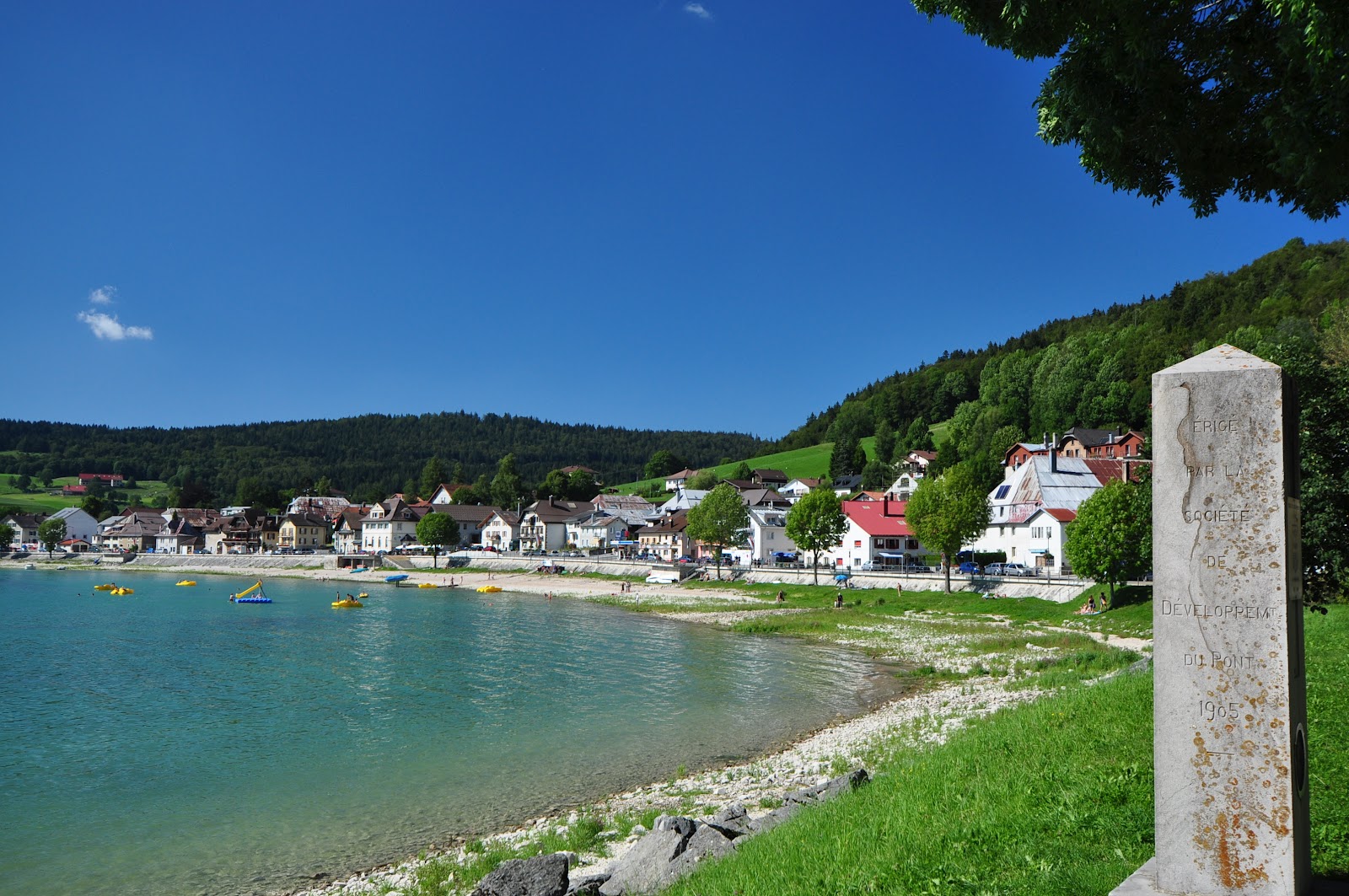
The village of Le Pont - nestled into the northern end of Lac de Joux, August 2011.

Le Pont in mid-winter colours - January 2011.
We didn't stop to take any photos of the town today, after arriving there at about 10.30, and parking our car in a car-park on the eastern end of the tiny strip of settlement wedged between the lake and the mountainside. The village was originally called "Le Port", which was changed to "Champ du Pont", then to "Les Petites Charbonnières", and "Vers-le-Pont", before finally being changed to "Le Pont" in 1601 - following the construction of a bridge in the 16th century, which connecting the tiny settlement to the larger village of Les Charbonnières, which is located just to the southwest. Le Pont is also strategically located right at the western foot of the Col de Mollendruz, and more or less marks the north-eastern end of the Parc Jurrasien Vaudois.
It's a magic place, in a magic valley, alongside a magic lake.

Lis at Lac de Joux, June 2008.
We often come here when out day-tripping, or motorcycling - as it's a great stop-off point for a cup of coffee on the lakeside terrace of one of our favourite tea-rooms - anywhere in the world. It's always lovely to take a stroll around the lake (Lac de Joux), or (very rarely) a dip in the lake's icy waters, or to "smouze" through the local brocante (antique and second-hand store).

Our favourite tea room at Le Pont, June 2008.
Lac de Joux is the largest lake within the Jura massif, nestled in the Vallée de Joux, and is a popular place for sailing, kite-surfing, boating, fishing, picnicking and, in winter, ice-skating. When it's fully frozen-solid in mid winter, it can attract hundreds of ice skaters on any weekend to make the most of this huge natural rink. It's a wild and rugged landscape, especially in mid-winter, when smothered by layers of snow. "Joux" means "rock" in an ancient local dialect, but also has the same origin as "Jura" from Medieval Latin juria and Gallic jor, juris, meaning literally "height wooded" and referring to a mountainous place covered by a forest of tall trees. The name is probably meant to refer to this "Lake of the Jura".
The lake turns rock solid in winter mainly due to the fact that the Vallée de Joux generates its own frigid mid-winter micro-climate, with conditions more akin to much higher Alpine landscapes, even though it is only at about 1000 metres in altitude. Temperatures in mid-winter can get down to minus 20 degrees Celsius, with accompanying "arctic-like" winds. Vallée de Joux is a long, thin valley between the (Swiss) "Mont Tendre range" (on the eastern side) and the (French) Le Grand Risou escarpment and pine forest (on the western side).
It's not surprising that the first permanent residents of the vallée were hardy monks. They turned-up here more than a thousand years ago and established a tiny settlement on the eastern side of the lake, just south of Le Pont, at a place now called L'Abbaye. They called it Abbatem de Lacu (in 1140), which became Abbatia de lacu Jurensi in 1228. At one time, the monks of the Abbaye de Joux (as it was by then called) owned and controlled the entire valley - a situation they apparently enjoyed until they were evicted during the Reformation. Even by 1700 there were only 173 inhabitants living in the vallée (and 22 bears).

The old church, and adjacent ruins at L'Abbaye.
Taken during a motorbike trip in June 2008.
Another interesting thing about L'Abbaye is that it also has one of the extensions of the "Toblerone Line" - the line(s) of concrete anti-tank defence barriers that were built across southwestern Switzerland in the late 1930s, around the start of the Second World War. It was officially (and originally) called the "Promenthouse Line - Promenthouse being one of the three rivers along which the first (toblerone-chocolate-shaped) blocks were constructed. (The others being the Sérine and Combe). There are a couple of strategic extensions near the Lac de Joux: this one near L'Abbaye and a second one in the hills above Le Pont between L'Aouille and the village of Petra Felix. The "line" of 16 tonne blocks snakes its way from the heart of the Jura Mountains all the way down to Lac Léman

The section of the Toblerone Line between L'Abbaye and Lac de Joux.
Like the ancient monks of L'Abbaye, and the durable blocks of the Toblerone Line, "Les Pontounets", as the Le Pont locals are called, are hardy folk. Between 1880 and 1936 (before the age of refrigerators), they used to cut giant blocks of ice from the lake and temporarily store it in a huge shed just opposite the railway station, before shipping it off for cool rooms in Geneva, Lyon and Paris.
With the ice industry long gone, the Vallée de Joux's main claim to fame is its watch-making heritage, with such famous labels as Audemars Piguet, Jaeger-Le Coultre, Breguet and Blancpain still producing magnificent hand-crafted time-pieces in the towns of the valley. Of course, the vallée is also famous for its lake, its cheeses, ski-slopes, walk-trails and Jura summits - which is what attracted us here today.

Trail-sign in Le Pont (1008m).
We were headed-up one of the most distinguishable peaks in the Jura - the Dent de Vaulion, which towers over Le Pont (to the south), and the nearby village of Vaulion (to the east) - after which the mountain was named. (The village dates back to 1097, when it was originally called "Vallem Leonis" (Lion Valley). Its name was changed to Valleuni in 1160, then to Valiom in 1263, then to Vaulion in 1316, and finally to Vaulion in 1467, still essentially meaning "Lion Valley". "Dent", of course comes from the Latin word dens, dentis, meaning "tooth" - which is applied metaphorically to lots of tooth-shaped summits throughout this part of the world.) We left the car-park at about 10.45 and headed up a trail at the eastern end of the town which led (eventually) to Dent de Vaulion. It's quite a feature in this part of the Jura, dominating the landscape at the head of Lac de Joux. Not surprisingly, it has been marvelled at, and revered, by successions of inhabitants and passers-by. At one time it was called "Dent Chichevaux".
We stopped after about 15 minutes to take the first photos of the day - of one of the famous anti-tank barricades (a part of the "Toblerone Line") on a road just above the village. This one was strategically positioned in a narrow gorge between two foothills above Le Pont - Les Agouillons (to the north, 1168m) and L'Agouille (to the south, 1147m).

The circles in the road used to contain anti-tank mines (during the second World War).
Not long after passing through the gorge, we cut through one of the most popular places around here for botanists and wildflower-lovers - the Sagne Vaugnard wetlands (at 1070m) which were a blaze of yellow, pink, purple and white flowers. It was a gorgeous summer display of alpine wildflowers, which continued to change as we got higher up the limestone slopes of the mountain.

Lis among some wildflowers just near La Dent farmhouse (1194m).
Much of the route thus far had been easy going, on forestry access roads and farm tracks. We'd gained about 200 metres in altitude and by the La Dent farmhouse (called "Petite Dent Dessous" on old maps - 1194m) were already starting to get some good views of the vallée and lake.

Lis looking back at La Dent farmhouse.

Lac de Joux from above La Dent farmhouse.
The next landmark on the trail, which was by now a bit more rustic, and steep, was Le Petite Dent farmhouse (or "Petite Dent Dessus" on old maps - at 1348m) - from where we had even better views of the vallée and lake.

The view from above Le Petite Dent farmhouse.
With the summer pasture in full bloom, and lush with all kinds of herbs and grasses, not surprisingly, we also began encountering our first herds of cows enjoying their summer retreat in the alpine meadows. The noise from their bells was so loud, it was like being in the middle of a hundred-bell call-to-service in a city of churches.

Lis conversing with one of the noisy bell-ringing locals.
After one last push, up a steep slope at about 1400 metres, we arrived within view of the summit, at the refuge run by the Vallorbe Ski Club.

Lis passing the Vallorbe Ski Club hut (1412m) near the summit of Dent de Vaulion.
The 20-25 bed refuge, built in 1949, is tucked away just behind the Chalet de la Dent de Vaulion (1410m), which is a popular dining spot at this time of the year. You can drive right up to its doorstep (except in winter, when the roads are covered in snow and the restaurant is closed), and get served its specialty dish of cheese fondue (between May and October).

Looking back towards the Chalet de la Dent de Vaulion.
We pushed-on, a little further up the slope to the summit of the mountain (1482.6m), where we were greeted by lots of other hikers ... and a mob of cows. It was just after noon, about 1 hour 20 minutes after we'd left Le Pont.
A lot of the visitors enjoying the views from the summit were from the restaurant, merely ducking-up to the top for a quick view before settling down to a table on the restaurant terrace for a hearty serve of cheese fondue. Fortunately that wasn't our plan for lunch and, having found a lovely patch of grass among the rocks on the eastern slope - with magnificent (although a bit hazy today) views towards Mont Blanc and the rest of the Alps - we settled down for a picnic lunch.

Lis taking it easy at our lunch stop.

A boot view of the eastern Jura and distant Alps.
On a good day, the views from the summit of Dent de Vaulion are among the best in the Jura. It is the only summit from which you can see the three biggest lakes in the region - Lac Léman, Lac de Neuchatel and Lac de Joux. Across Lac Léman, there are wonderful views of the full arc of the Alps, from the Bernese Alps to the Savoy Alps, with Mont Blanc most prominent, along with the Dents du Midi. We pulled our binoculars out and checked-out the Matterhorn and lots of other summits. We'd scored a lovely clear day for this particular Jura Mountain ramble.
The famous German writer, poet, philosopher, naturalist and adventurer Johann Wolfgang von Goethe climbed to the top Dent de Vaulion on the 25th of October 1779. This is his description of the view of the Alps:
"Under a bright and clear sky nothing was visible but the high mountain chain, all the lower regions were covered with a white sea of cloudy mist, which stretched from Geneva northwards, along the horizon and glittered brilliantly in the sunshine.
Out of it, rose in the east, the whole line of snow- and ice-capt mountains acknowledging no distinction of names of either Princes or Peoples, who fancied they were owners of them, and owning subjection only to one Lord, and to the glance of the Sun which was tinging them with a beautiful red. Mont Blanc, right opposite to us, seemed the highest, next to it were the ice-crowned summits of Valais and Oberland, and lastly, came the lower mountains of the Canton of Berne."

Under the geodesic pyramid at the summit of Dent De Vaulion.
In the background the ubiquitous radio transmission aerial.
I wandered around the hill-top for awhile taking photos - of the circular orientation table (you sure can see a lot from this vantage point!), and then of some of the spectacular views. As well as the three lakes and the Alps, you can see other Jura top 60 peaks - to the north Mont d'Or, to the northeast Le Suchet and Aiguilles des Baulmes, and to the south and southwest Le Risel, Mont Tendre and La Dôle. To the southwest is Le Mont Risoux - the dramatic, forested escarpment that rises on the western side of Lac de Joux and marks the Swiss-French border.
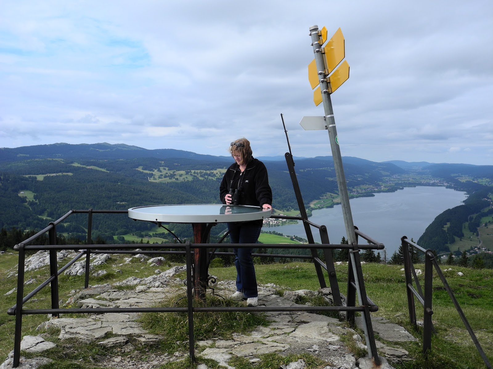
The orientation table at the summit of Dent de Vaulion.

Inscription on the orientation table, Dent de Vaulion.
To the north you can look down on the town of Vallorbe - in the valley of the Orbe (Vall-orbe), one of the biggest centres in the Jura.

View towards Vallorbe.
Also just below the steep Cote de la Dent on the western side (on the road between Le Pont and Vallorbe) is the Chalet du Mont d'Orzeires - which is the headquarters for the "Juraparc" (or Jurassic Park) and its collection of wolves, bears and bison.

One of the wolves eyeballing me in Juraparc, July 2009.
On the western side of the summit is a wooden ramp for paragliders to launch themselves out into the updraft from the Col de Mont d'Orzeires. It's a popular place for throwing oneself off a mountaintop. It is also a popular ski location in winter, and has a ski-lift and ski resort operating when the mountainsides are blanketed in lovely, white, powdery snow.
Also nearby are the Grottes de Vallorbe caves and the Source de l'Orbe - the headwaters of the Orbe River. By a quirk of nature there are no rivers or streams flowing out of Lac de Joux. Instead, the waters drain from the lake via underground karst streams which flow for about two kilometres underground before reappearing in the Grotte de l'Orbe. As well as being pocked by hundreds of karst holes, the mountain has also been drilled like Swiss cheese with numerous old mine shafts - the legacy of a gold rush that was sparked when an accidental prospector found gold nuggets in the Rivière des Epoisats stream on the west side of the mountain late in the 18th century. The miners who turned-up to seek their fortune not only dug new pits into the already pock-marked mountain, but also dug into the walls of some of the existing natural caves, as evidenced by the relics and shafts later found in the Grotte-Gouffe du Gnome ("Pit-cave of Gnome").

Le Suchet and the town of Ballaigues to the north.
Other peaks (to the left) include Le Chasseron and (in the centre) Aiguilles des Baulmes.
Immediately below our lunch-spot we could see the town of Vaulion, and the road running northeast from the Col de Mollendruz towards Romainmotier - another of our favourite villages in the Jura. Romainmotier lies in Le Noxon valley just on the eastern edge of the Jura, almost hidden in a last valley before the Jura opens out onto the Lac Léman plain. It has a wonderful old Romanesque church/abbey - built on the ruins of a former monastery (that dates back to the 5th century) by monks from Cluny between 990 and 1028 - and equally wonderful nearby tearooms. The church has amazing Gothic columns and frescoes from the 14th century, and beautiful old bum-polished wooden choir stalls from the 15th century. The site is thought to be the oldest of its kind on Swiss soil.
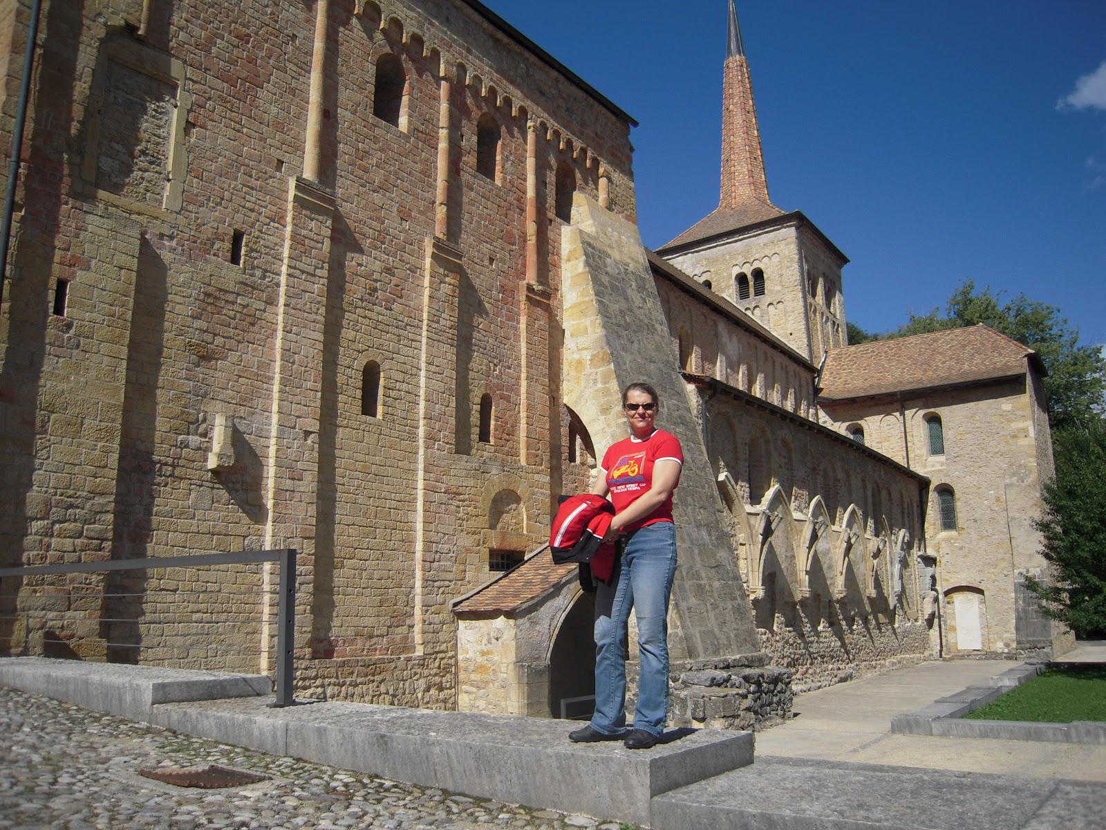
Lis in front of the old Romainmotier church, in July 2009.
The tearooms are located in the adjacent 13th century Prior's House, which also houses a museum and serves as a meeting point for local artists. Around the end of the 13th century, Romainmotier was a stopover point on a branch of the Pilgrims Road between Aix La Chapelle and Satiago de Compostela. We've stopped-over a few times in Romainmotier for coffee, cakes and quiet moments of reflection in the ancient abbey. It's another wonderful, hidden secret of the Jura.

An Alpine arc from Dent du Midi to Mont Blanc on the eastern horizon.

A closer view of Mont Blanc.

Signpost at the summit of Dent de Vaulion.
We'd been up here as recently as November 2011 - with Lis' brother Denis and his wife Gill.

Lis near the top of Dent de Vaulion with views of Lac de Joux,
the town of Les Charbonnières and Lac Brenet (to the right).
At around 1pm, we left the summit and began making our way back down the mountain. We soon passed-by the nearly fully occupied terrace of the Restaurant de le Dent de Vaulion - at which nearly every table had a cheese fondue bubbling away.

The Chalet de la Dent de Vaulion.

Sign on the wall of the Chalet de la Dent de Vaulion,
showing a nearby WW2 underground fortress.
We gawked as we passed, paused awhile to have a look at a sign on the southern wall showing the design of a nearby underground World War Two defence installation, then headed down the mountain.

Heading down towards Lac de la Joux.
Along the way we reunited with a mob of mid-slope cows and then, in an absolute treat, came across a family of stoats jumping in and out of the cavities of an old dry-stone wall. We stopped to watch them for about five fascinating minutes, until they called the game to a halt and disappeared into the crevices. That was something special!

Hey, you again?
We arrived back in Le Pont at about 2pm, an hour after we'd left the summit, and took a breather on a bench at the side of the lake, before finally heading back to the car ... and then home. It had been a great walk, and had fully lived-up to its reputation as being one of the very best hikes in the Jura.
Jura peaks bagged:
- Dent de Vaulion (No. 48) 1483m
- JW Goethe also climbed the nearby Jura peaks of Le Noirmont and Dent de Vaulion in late October 1779. He wrote of his time in the Jura: "If only destiny had bidden me to dwell in the midst of some grand scenery, then would I every morning have imbibed greatness from its grandeur, as from a lonely valley I would extract patience and repose."
- According to the folks at peakery.com, Dent de Vaulion is the 6,220th highest mountain in Switzerland.