Tuesday, December 24, 2013

Crêt Pela (No 46)


Hiking to the top of Crêt Pela is more about enjoying a good walk in the forest than about getting to the top of a Jura mountain with amazing views: It really only has glimpses of Mont Blanc and the Alps from the summit, as the ridgetop is somewhat shrubby, and surrounded by dense coniferous forest. But it does provide a destination for one of the most popular walks in the Franche-Comté - where it's notable for being the highest point in the province, as well as the French Departement du Jura (one of the four departements in Franche-Comté).

Our starting point at Lac de Lamoura (1155m).

We started today's walk at about 11am - from a parking spot called "Gouffre" at the southwestern end of Lac de Lamoura - which is about a kilometre east of the town of Lamoura. (Lamoura is a small Jura village in eastern France, just over the border from Switzerland near the Col de la Faucille.)
It was a lovely sunny morning, with just a few clouds in the sky, and a forecast for a mixture of more sunshine, and some clouds, throughout the day. Perfect for a Jura walk.

Blue skies at the start of the walk at Lac de Lamoura.

We skirted around the south side of the lake, treading gingerly across the slippery walk-trail that was being kept hard and icy by the near-zero temperatures, and early-morning shade from the Jura ridge immediately southeast of the lake - the ridge that runs southwest-northeast between the peaks of Crêt Pela and Crêt de la Vigoureuse.

Just a hundred metres or so around the lake, we turned right, and followed a narrow goat-track uphill that led us to a point called "Sur le Lac" (1200m), and a trail that ran parallel to the lake called "Sentier de Decouverte".

First trail sign - at Sur le Lac (1200m) - on the Sentier de Decouverte.

From there, we turned northeast ... and followed the "sentier". It mostly followed the contour, on the heavily forested lower slopes of the Bois sur les Champs - which covered the entire hillside and ridgeline above us.

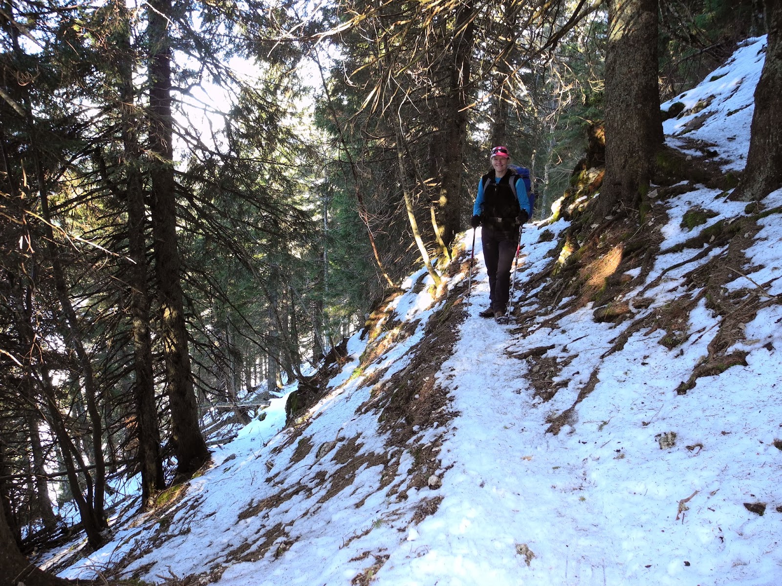
We'd taken a bit of a gamble with this walk in deciding to do the trip without snowshoes (mainly because it hadn't snowed for a couple of weeks, and because we'd done our last walk to the top of Les Ervuines without snowshoes last weekend - which had been relatively easy). But some of the slippery slopes and deeper patches of snow already had us wondering if we'd made a mistake. Quite often we sank through the soft snow or icy crust, including a couple of times when our boots sank into the semi-frozen muddy slush that was hidden underneath the white carpet.

Getting warm (and shedding layers) on the Sentier de Decouverte.

It didn't take us long to cover the first kilometre or so from Lac de Lamoura, and we were soon approaching the next landmark on our route - the alpage farmhouse called Les Thoramys. There are a couple of other buildings in the vicinity (now all shuttered-up for winter), so we stopped just long enough to take a few photos, then carried on our way - still heading northeast on the same long traverse that steadily climbed up to about 1300 metres.

Farm alpage near les Thoramys.

We stopped at Les Thoramys (1243m) just long enough to check the map ... and to collect my hat which had blown off in a ferocious gust of wind that hit us once we'd reached the open ground near the alpage. We'd noticed the wind picking-up speed as we were driving down from St George earlier in the morning, and had hoped it wouldn't be too much of a spoiler for our hike ... but the signs were not promising. Making matters worse, the fierce wind - now coming at us with increasing intensity from the south - was bringing with it an ominous wall of grey-black cloud. Off to the north and west the skies were still mostly clear and blue, so we kept our fingers crossed, turned our backs to the clouds and wind, and forged ahead.

Trail sign near Les Thoramys.

Les Thoramys alpage (1243m).

About a kilometre from Les Thoramys, our trail then began intersecting a series of teleskis and ski pistes (although most of these were not in action) that ran from the upper slopes near La Serra (1452m) down to the valley floor near the small ski resort village of l'Abbaye. Each time we passed either a teleski chairlift or piste, we got good views down to the valley floor - seeing first La Combe du Lac, and soon after, l'Abbaye.

The tiny settlement of la Combe du Lac.

The first major ski piste that we came to was the southern-most piste (of a series) that flowed down the mountain-side from the top of the Teleski de la Serra, past the Point de Vue du Lac (1320m). Due possibly to the small amount of snow on the piste, it wasn't in operation today, so we had an easy, casual passage to the other side. At this point we decided to not follow the usual walk trail - which dropped down the side of the hill to follow another traverse at about 1275 metres - and instead stuck to the forest trail that we were on (the Rte Foret des Auvernes), a couple of hundred metres higher-up the slope.

Trail sign at Point de Vue du Lac (1320m).

Cutting across one of the ski pistes near la Serra. This one wasn't in use.

The Telesiege des Auvernes was in use, and we stopped to watch skiers and snowboarders come racing down the mountain on the main piste just a little further north along the trail - the most northern piste of the series. When the coast was clear, we quickly made our way across the piste, without managing to get in anyone's way in the process.

The Téléski des Auvernes.

Skiers heading down the piste des Auvernes - above l'Abbaye.

About a hundred metres further along the road we encountered the walking trail again - coming back up the mountainside - so we turned east onto that and started cutting footsteps into the snow up the steep slope. Fortunately someone had been up here fairly recently wearing snowshoes, so the trail was reasonably well compacted, meaning we didn't break through the surface too often and sink into the softer snow below.

Heading up the slopes immediately west of Crêt Pela.

We were now heading into some rough-and-tumble country - the infamous "Foret du Massacre" - which is a dark coniferous forest (almost entirely composed of fir trees) which had been the scene of a brutal massacre of Italian soldiers in 1535. Apparently, a contingent of 600 Italian mercenaries - commanded by Renzo de Cery and dispatched by Francis 1 at the request of the King of France - had met grisly deaths there after a failed mission to reach (and rescue) Geneva which was under siege by the Savoyard army led by the Duke of Savoy, Charles III. In a rapidly unfolding tragedy, the mercenaries were "headed off at the pass" - quite literally - at the Col de la Faucille within view of Geneva after marching up from Genoa, and chased into the wild Jura forests by the Savoyards. Once reduced to a fleeing, disorganized rabble by the rough-and-tumble Jura rocks, ridges, cliffs, grottes, caves, fallen trees, and more, they were steadily picked-off by their more locally-experienced adversaries. Apparently before the slaughter, the forest had been called Foret Frasse (or simply "la Frasse"), but the locals who witnessed the carnage later decided to rename it - the Foret du Massacre.

Unfortunately, we too fell victim to the rocks, ridges and rolling landscape, and, soon after having to leave the footsteps of the snow-shoers (they had turned north, soon after they'd passed a point marked "Grotte" on the map), we were forced to cut our own trail across the hilltop. Although obviously still on some kind of trail, we couldn't tell exactly if we were still on the walk-trail or not, as we were focusing our attention on the ground below us - sinking up to our knees in the deep snow with every step at the top of the ridge. It was hard-going, and physically draining. Damn, why hadn't we brought our snow-shoes?

Rugged-up against the near-Arctic conditions we experienced on Crêt Pela.

With the wind now howling around us, and clouds completely blocking-out any distant views, we reached the top of the ridge, where we plunged into the deepest snow we'd encountered thus far and bush-bashed our way to what looked like the highest point. Although we were quite sure that we were very close to the top of Crêt Pela (it was no doubt nearby, but hidden behind the trees and thicket), we couldn't find the summit-marker wooden post and small "Crêt Pela - 1495m" sign that should have been there. My altimeter was showing we were up at the right altitude. No matter, we were close enough for our liking! So we took a "top of the mountain" celebratory photo anyway, and then made a mad dash to get out of the freezing, wind-blasted conditions. It was about 1pm, yet felt like it was nearly the end of the day.

Standing on top of one of the peaks of Crêt Pela.

We didn't have to go too far back down the mountain on the lee side, to find a sheltered place out of the wind, and we were soon bunkered down under a big fir tree whose branches provided a teepee-like shelter under which the two of us could enjoy our lunch. We sat there with our tea and sandwiches, and listened to the ferocious wind screaming and howling above us. It made me think of the screams of those tormented mercenaries who were lost in the surrounding forests and hunted down by the Savoyards 500 years ago.

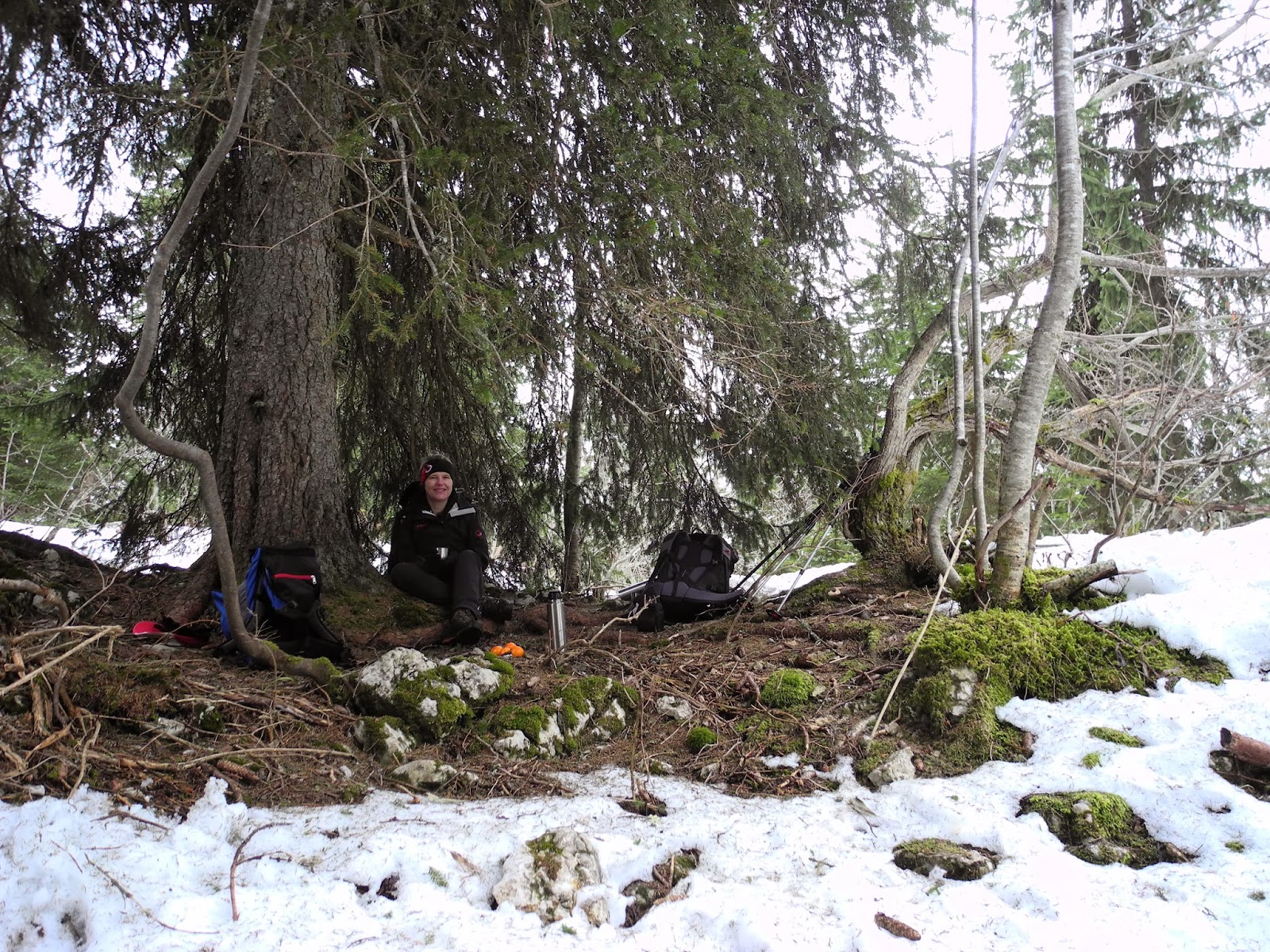
Our lunch spot - in a hollow, sheltered under a tree.

Our original plan was to have lunch at the summit, and then follow the walk-trail that skirts around the western side of the peak - to the northeast, before turning back on a long southwest traverse on the other (eastern) side of the ridge. But not having snow-shoes, and being acutely aware of the deteriorating weather conditions, we decided to abandon the circular route, and head back down the mountain the same way we came.

Being a little off the summit due to our rapid search for a lunch stop, we had to again cut a new course back to where we'd last seen the snowshoe tracks - which meant that we found ourselves in some relatively tricky spots on a couple of occasions in the deep snow. Three or four times we plunged into hollows in which we sank down to the top of our thighs. On one occasion I tripped forward when this happened, and thus found myself face-first in the snow, with neither my feet or my hands able to get enough of a grip to haul myself back out. Fortunately of course, we managed to get back to the trail, and were soon heading back down the mountain, shaking snow out of our boots and socks and grinning happily. It was good to be back on a hard trail surface again.

Hard going: Trail-blazing our way down from the summit.

It didn't take us long to get back onto the Rte Foret des Auvernes, where we turned southwest and began the long traverse back towards Lac de Lamoura. We hardly stopped the entire way back to the car-park, intent now on just getting off the mountain, out of the wind and cold, and home to a hot bath and open fire. Before we knew it, we were back at the lake, although this time we dropped down the mountain by following the unused ski piste at the Point de Vue du Lac - to the Combe du Lac. There, we joined another walking trail that led us to and around the eastern end of the lake, then along its left bank to the Gouffre car-park.

Back down alongside the Lac de Lamoura.

Most of the lake was frozen ... and we had no intentions of traversing.

Needless to say, it didn't take us long to drop our packs into the back of the car, and to start the 45 minute drive back through the Jura to St George. It had been an adventurous walk, but I suspect we'll be back (in sunnier, more summery weather) to have another ramble through this part of the Jura.

Jura peaks bagged:
  • Crêt Pela (No 46) 1495m

Trivia:
  • "Pela" means a mountain or a land peeled, naked ... which is nothing like the heavily forested and shrubby top of Crêt Pela today.
  • The Foret du Massacre is in the Parc Naturel Regional du Haut Jura. In writing up this blog, I also found out that it is also a refuge for Grand Tétras and lynx, and is declared a Natura 2000 reserve. Winter walkers are encouraged to keep off the marked ski pistes, but probably should avoid the area altogether, and save their hikes there for the spring, summer and autumn. Now that we know about its natural significance and level of protection, we certainly will be doing so from now on. 

Monday, December 16, 2013

Les Ervuines (No 30)


Les Ervuines is one of those peaks that hundreds of people must walk past every year, yet most of them would know nothing about it, or have ever even heard of its name. If you search for information about Les Ervuines, you won't find much, and you'll even see it referred to as "Les Erouines" (with an "o" instead of a "v") ... which is because the "v" looks a bit like an "o" on the topographic map (Carte Nationale de la Suisse, 1:25,000, 1202, Orbe). Even so, it does appear on registers of named Swiss peaks and, being on my list of Jura peaks at "Number 30", was ready to be ticked-off this fine Sunday morning (15 December, 2013).

At least it was "fine" in St George when we left home, and it was "fine" in Baulmes when we arrived there to start our walk. But it was far from "fine" all the way between these two end-points - as the entire Swiss Plateau below about 500 metres was enveloped in a typical winter "Mer de Nuage" (Sea of Clouds) that smothered any sign of there being a fine day in the mountains above. So it was fabulous to emerge again from that fog - as we drove up towards Baulmes, and to see Les Rebans and Mont de Baulmes shining in the morning sun above the town.

As per our last visit to the town, we parked just near the old church (678m.a.s.l.) and, at about 10.30am, started heading up the hill out of town. (We were last here in July, when we climbed Aiguilles de Baulmes, Les Rebans and Mont de Baulmes. You can read about that trip here.) Just after we'd crossed over the the Baumine River - that runs through the town - we turned left onto a small side street called the Rue de la Montagne and headed north out of town.

The turn-off at Rue de la Montagne.

After passing just a few houses along the road we got onto a pleasant, leaf-littered forest trail that meandered uphill, alongside the Baumine. It was immediately a soothing feeling to be walking in the forest with a bubbling brook singing-out alongside us as we walked. Just 15 minutes up the trail, we intersected an icy road, with an equally icy bridge, that marked our first real way-point of the day. Last time we were here, we headed straight-on, up the hill towards Mont de Baulmes. But this time we turned left, across the bridge, heading west-southwest in the direction marked "Le Suchet: 2h 30 min: Sentier de la Crête".

The trail sign pointing towards Le Suchet.

Crossing the bridge just northwest of Baulmes. The "Sentier de la Crête" can be seen heading up the slope in the snow in the centre of the photograph.

After gingerly slip-sliding and skating our way across the bridge (we'd decided to take a punt on leaving our snow-shoes behind today, and to do all of today's hike in just our walking boots), we equally gingerly negotiated the first icy steps of the slope - that would eventually lead us all the way to Les Ervuines, and Le Suchet further beyond.

Heading-up the icy "Sentier de la Crêtes" trail towards Le Suchet.

No fresh snow has fallen on the Jura for the past two weeks, and having had an intervening period of sunshine and rain, much of the lovely blanket that we'd walked on to the Haut du Mollendruz was now gone. However there were still patches of snow - either on the highest peaks, or in sheltered and shaded aspects, and in some places this had partially melted before being refrozen as long swaths of ice. Not surprisingly, we nearly took a few tumbles as we negotiated the first, steep rise on the northern side of the ridge that we were ascending, but were soon onto the ridgeline where the sun had pretty much burnt away all of the ice and snow. This ridge defined this walk ... as we were pretty much on it for the entire rest of the ascent - from Baulmes to Les Ervuines.

Heading up the ridgeline.

All along the ridgeline we passed a series of substantial milestones, and I couldn't help but think we were missing something significant about this ridge. Did it mark a boundary of some description? It didn't look like it from the map, so it left me wondering. We also passed a point on the map marked "Fortification Prehistorique de l'Ermitage" - which apparently marks a site which dates back to the prehistoric cave-dwellers and early hunters and gathers who settled in the hills around here about 12,000 years ago.

One of the impressive trail-markers near the "Fortification Prehistorique de l'Ermitage".

All of this first part of the walk was through dense mixed deciduous and coniferous forest, which made for very pleasant conditions: Lots of shade, lots of leaf-litter underfoot and gorgeous surroundings filled with moss, lichens and vegetation in every stage of growing, dying and decaying. It really was a beautiful way to spend a Sunday morning. In some places millions of fir leaves (tiny thin "needles", about a centimetre or two in length) covered the patches of snow like "hundreds and thousands" candy. About a kilometre into our walk we reached the crest of an un-named hill - at 1079m - from which we then headed downslope

Passing the 1079 highpoint between Baulmes and Les Mouilles.

We quickly dropped down to about 1050 metres - where we encountered a snow-smothered roadway that cut over the mountain ridge just east of the "Les Mouilles" farmhouse. Both the road and the farmhouse were closed for winter. We crossed over the road, and headed on up the ridgeline - further along le Sentier de la Crête.

Trail sign near Les Mouilles - 1050m.

This marked the beginning of an amazing uninterrupted climb up the mountain. Not once did it dip back down, but instead continued on ... up, up and up, at a gradient of about one-in-five. Sometimes it felt like we were on a rough-cut staircase. Sometimes we really were, as we climbed about 1,000 metres in vertical altitude in about a four-and-a-half or five kilometres of horizontal distance. The ridgeline became even more pronounced - more like an arête - with steep slopes dropping away on either side of us. At times the top of the ridge was less than a metre wide, so we took particular care with where we placed our feet in those places. The steep slopes to our left (the southern flank) are called La Côte (the hillside), while on our right (the north "face") were the slopes and cliffs of Les Ervuines. It truly was an amazing trail, and we were loving being on it.

Heading-up the Les Ervuines ridgeline.

In other places, the route became a tangle of fallen trees, decaying logs and "untidy" undergrowth. It sure made for an interesting hike.

Winding our way through some of the wilder stretches of the trail.

The higher we climbed, the more the forest canopy thinned-out, which occasionally afforded us glimpses of the landscape beyond the surrounds of our immediate forest. Most imposing - to our north - were the cliffs and rocky crags of Aiguilles de Baulmes. Below their cliffs we could see the Les Prax, Les Crébillons and Les Nax farmhouses, now all abandoned for winter of course.

The striking cliffs and crags of Aiguilles de Baulmes.

At about 1430 metres (in altitude), we broke out of the forest and for the first time got a clear view of the Alps far to the south, and the intervening "Mer de Nuage" that blanketed the Swiss Platueau. It truly was a glorious sight on such a sunny day, and it felt so good to up here above the clouds. Now out of the shade of the forest, we were in glorious sunshine ourselves - for the first time really, so we stopped briefly for an energy bar and sip of lemon water, and to take a few photographs of the scenery around us, including of some of the gnarly old mountain trees - some of which were still standing, while others were fallen, lying like sun-bleached skeletons across or near our trail.

 
A fallen tree lies half-buried in the snow, with the Mer de Nuage and the Alps in the background.

Intriguing shapes and shadows from these two trees that obviously lived (and died) very close to each other.

A typical, weather-beaten Jura Mountain tree.

Approaching 1500 metres, the ridgeline became more pronounced again, and conveniently (in case one ever got stuck up here in a winter white-out or blackened stormy night) was marked by a line of somewhat rickety fence posts. Once again we stopped to take in the views, and to take a few photos of the world around us. It truly was spectacular.

Looking back - northeast along the ridgeline - towards the northern Jura, with Le Chasseron on the upper left horizon over Mont de Baulmes.

Looking south over the Mer de Nuage towards the panoramic arc of the Alps.

A closer look at the Alps (with the Dents du Midi on the right - wearing a halo of clouds), and the Mer de Nuage below.

Approaching the highest point of Les Ervuines.

At about 1pm, two-and-a-half-hours after we'd left Baulmes, we reached the highest point of Les Ervuines - 1538 metres. It was marked by a crumbly-looking cairn, which looked hastily built with not a lot of attention to aesthetics, and a steel pole alongside a rock on which someone had scrawled "1540" in red paint. (It's actually registered as 1538m on all of the lists that I've come across, so that's what it's going down as). Not surprisingly (because it's not on everyone's list of burning places to visit, and also being so close to the higher, and more distinguishable, adjacent Le Suchet summit), we had the peak all to ourselves. We found a great vantage point to sit back and gaze at the Alps while we ate our lunch.

The name "Ervuines" is thought to be derived from an ancient word rouvenes and old French word ruvines - which means "sloping ravine" or "scree". It also means "ruins". In base Latin, it is derived from ruina - which means ruins, but also (appropriately - given where we were standing on the clifftops) "fall, collapse, disaster". We'd be having none of that thank you!

After lunch, and a lazy half-hour of Alp-gazing, we took a last look around the peak before heading on our way. Being "nullarbor", it was possible to get magnificent, uninterrupted 360 degree panoramas. We snapped-off the usual "we were here" type photographs.

Standing alongside the unremarkable cairn atop Les Ervuines.

Looking northeast back along the Les Ervuines ridgeline and, in the distance, the rest of the main Jura ridge stretching-out towards the horizon.

Checking-out the Aiguilles de Baulmes from the crest of Les Ervuines.

A closer look at the cliffs of Aiguilles de Baulmes.

At about 1.30pm, we grabbed our backpacks, and headed on up the mountain. We were already three hours on the trail and were heading "out", rather than "back", so had decided to get a move on. From Les Ervuines we could see the steel geodesic pyramid atop Le Suchet, so hastened in that direction. Well "hastened" may be too strong a word, because we stopped quite a few times to gaze at the view around us, and to take a few more photos, of course.

A turnstile on the "Sentier de la Crêtes" trail near Le Suchet.

Lis standing on a cliff-top between Les Ervuines and Le Suchet (top left).

Looking north towards the Grange Neuve chalet (with the orange roof) and the Aiguilles de Baulmes.

Standing on the rocky ridgeline just northeast of Le Suchet.

Near Le Suchet, with the French towns of Entre les Fourgs and Jougne in the background, under Mont Ramey (1087m).

Obviously, it didn't take us too long to cover the last 650 metres  between the two peaks, and we were soon standing under the distinctive steel pyramid at Le Suchet (1588m). As I mentioned earlier, we'd been here almost exactly a year ago (on 25 December 2012), so we didn't stay too long this time - just long enough to snap-off a "selfie" to record the moment, and a few pics of the surrounding vistas, before heading on our way.

The Jura ramblers at Le Suchet.

Looking south from Le Suchet towards the arc of the Alps on the horizon.

We toyed with the idea of doing an out-and-back route that would mean retracing our steps, but the thought of heading down the steep icy ridge we'd encountered at the start of the day - in the last hours of the day, while tired - didn't sound like an appealing option. Fortunately we had two other options in front of us. One option was to drop down the south face of Le Suchet to the bottom of the mountain and then to pick-up a road or track heading north that would take us back to Baulmes. This would at least give us views of the Alps as we descended, and keep us on the sunny side of the ridgeline. The other option was to drop down on the north face of the mountain, and into the sheltered high-valley snowfields and to make our way back to Baulmes on roughly the same route we'd used when returning from Aiguilles de Baulmes in July. We "ummed" and "ahhed" about it for awhile, then chose the second option, and headed over the ridgeline and down into the steep forested slopes towards Grange Neuve.

As usual, the trail was well marked, so easy to follow. Fortunately, it was also nicely "stomped" down by a party of snow-shoers - who were walking some distance ahead of us.

A section of the trail through the forest just below Le Suchet.

Eventually we broke out of the forest and back out into the glorious sunshine. Below us, to our left, we could see the Noirvaux farmhouse, while up ahead of us Grange Neuve served as a distinctive landmark. We passed the snow-shoers, which meant from time to time we found ourselves in unbroken snow, but never more than about 20 or 30 centimetres deep, so not too hard going. Just good fun.

The Noirvaux farmhouse.

Heading towards Grange Neuve  and the Aiguilles de Baulmes.

Now down on relatively flat land, we followed a traverse that slowly cut across the contours and down to the farmhouse - at 1356 metres. Once again, we didn't hang around long. Grange Neuve is a popular buvette during spring, summer and autumn, but it was now closed for winter, so we just took a few photos, and continued northeast down the valley.

The Grange Neuve farmhouse, with an old WW2 machine-gun post on the hilltop.

Trail signpost at Grange Neuve.

The trail from here followed a snow-covered road along a gentle, valley-floor route which had Aiguilles de Baulmes on one side (to our left) and the cliffs of Les Ervuines to our right. With our shadows ever lengthening, and the afternoon light ever-warming, it was a magic way to finish-off the hike.

A last look at The cliffs of the Aiguilles de Baulmes.

Following our shadows away from the setting sun.

Our next way-point was a trail intersection near the Les Prax farmhouse, about a kilometre east of the Col de l'Aiguillon and the French border. We continued in an easterly direction, further down the valley - with Mont de Baulmes on the horizon ahead of us.

Trail sign near the La Prax farmhouse.

We passed by Les Crébillons and Les Nax farmhouses (also abandoned for winter), then plunged back into the forest, saying "goodbye" to the last rays of sunshine that we'd feel on our backs, as we did so. Occasionally we got glimpses of the sun shining on the cliffs of Les Rebans  and Mont de Baulmes high up to our left, but mostly it was shady and cold ... and increasingly gloomy. It wasn't all gloomy though, as we chanced upon three lovely-looking roe deer, that were content to just stand their ground in the forest and watch us ... watching them. Nice.

The cliffs of Les Rebans.

At about 1090 metres, we left the snow and ice-covered road that we'd been following since Les Prax, and turned right (south) onto a "rough-and-ready" hiking trail that took us more-or-less directly down through the forest - southeast towards Baulmes. At different times, it was either snowy, muddy, slushy, rocky or leafy underfoot, so we trod carefully as we slipped and slid our way down the last kilometre of the mountainside. Eventually we heard the bubbling sounds of the Baumine River again, and knew we were close to finishing our walk.

Back alongside the Baumine River just above Baulmes.

At about 4.30pm we arrived back in Baulmes - six hours after we'd departed from there earlier in the day. By now the sun had disappeared below the horizon, and a warm-coloured glow was lighting-up the clouds in the skies above. Unfortunately it wasn't too warm standing alongside the Baulmes church (it was about zero degrees), so we quickly dropped our packs in the car, and headed home to St George.

It had been a great day in the Jura, and another winning walk to add to our growing list of Jura Mountain rambles.

The last rays of light over the old church in Baulmes.

Jura peaks bagged:
  • Les Ervuines (No 30) 1538m
  • Le Suchet (No 19) 1588 (previously climbed on 25 December 2012. See report here.)