Crêt de la Neuve is one of my favourite peaks in the Jura. It's the highest peak on the Chemin des Crêtes transjurassien hiking trail between Mont Tendre (No 6) and La Dôle (No 7); it has one of the best views of Lac Leman and the Alps along the entire "Balcon du Léman"; and it's right above our home-town of St George. We've hiked up there before, in the summer of 2009 (July), when we had glorious sunny weather and views to die for; but today we just had itchy feet. And a trail straight-out of town, and up the mountainside, sounded like a great idea for a public holiday (Easter Monday, 2012).


We left the car in the car park in St George at 10am, and headed west out of town towards Les Devants - "the in-fronts" - as the first slopes of the Jura nestled behind our village are called. Before we left the village, we took some time to have a look at the marvellous wooden statues sculpted by local St George craftsman Paul Monney. There are something like 60 of his sculptures scattered all around this part of the Jura.


We hadn't got far into the forest before we were treated to a fantastic, tumultuous drumming display by a Great Spotted Woodpecker (Dendrocopos major) - one of the three species of woodpeckers that we get in our neck of the woods. (The others being the Green Woodpecker (Picus viridis) and Lesser Spotted Woodpecker (Dendrocopos minor). It turned-out to be a great day for wildlife spotting, as we saw lots of birds (including Red Kites and Common Buzzards), red and black squirrels, and even a red deer (Cervus elephus).

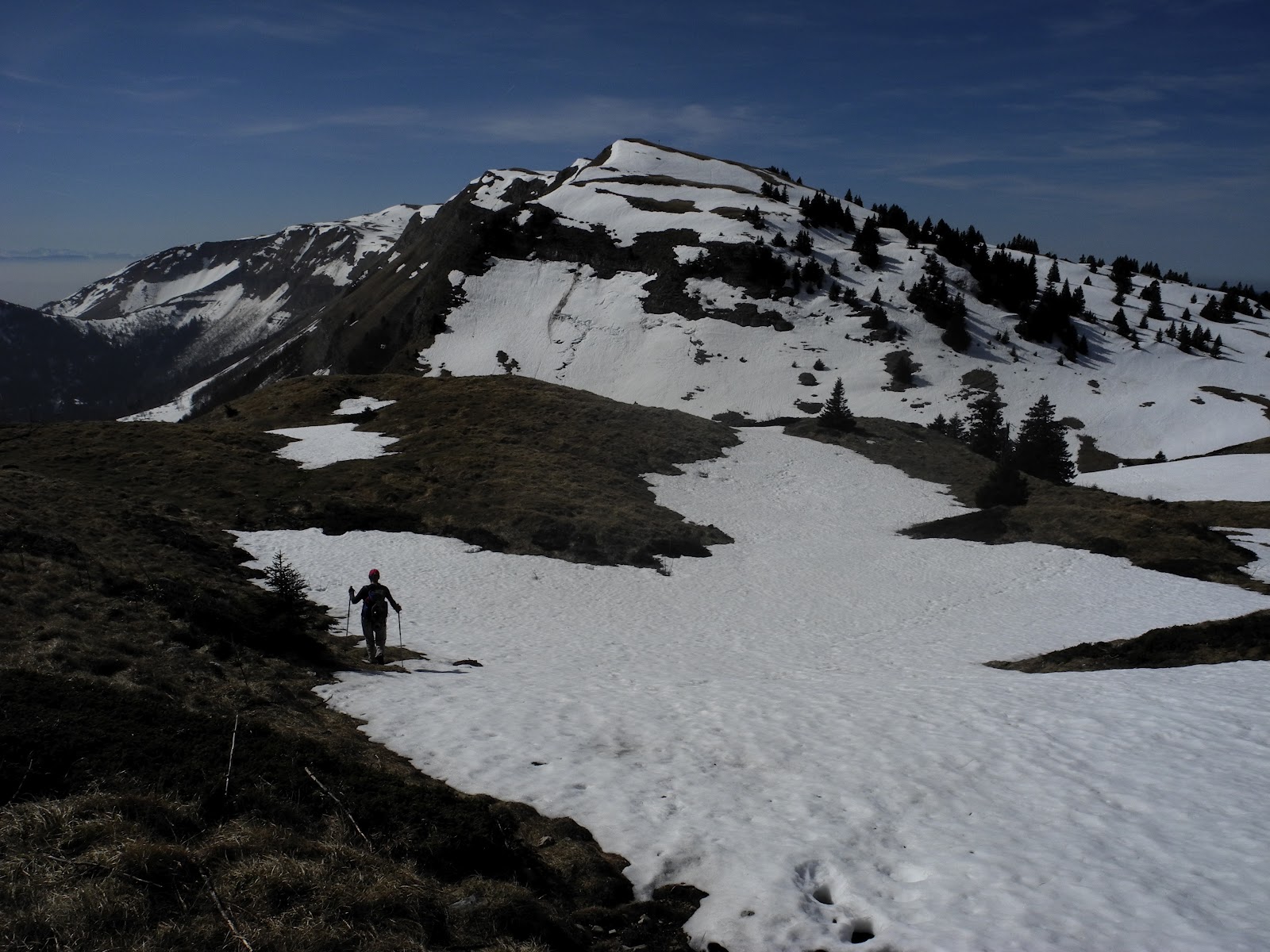
We soon reached the forest road that leads from Longirod to the distant and isolated La Neuve farmhouse (located on the other - northwest - side of the Jura crest, overlooking the Combe des Amburnex), so we turned right and took a trail less-travelled - a green-marked hiking track that led us straight-up the mountainside through the magnificent, silent, post-winter forest. ("La Neuve" actually means an isolated alpine house).

The "green trail" was a delightful track, mostly winding through the beech and fir forest, occasionally skirting alpine pastures (near Les Frasses, 1244m), and centuries-old dry-stone walls which served greater function in years past when pastoralism was the predominant industry in this neck of the woods. These days it's forestry and tourism which prevail, and the trees (which were largely chopped-out during the wood- and charcoal-hungry 18th and 19th centuries) have reclaimed the mountainsides and made the old walls largely redundant.

At about the same time the forests disappeared, so too did much of the wildlife, with deer, chamois, lynx, wolves, bears and a host of other critters hunted to local extinction around the same time. Fortunately, with the return of the forests (and 20th century conservation efforts), most of these have either reappeared, or been reintroduced, so it was a buzz when we spotted a red deer close to us among the trees.
Another interesting wildlife phenomenon in this area is the presence of the largest, and highest density, "supercolony" of wood ants (fourmis des bois) - believed to be the largest in Europe, and possibly the world, and sufficiently intriguing to have attracted David Attenborough and a BBC film crew up here in May 2005 to film an episode of Life in the Undergrowth. Fourmis des bois are "good" wood ants, as opposed to Fourmis du bois ... which are the termites that chew down your house.
The ants - which I believe are Formica paralugubris - build amazing nests up to a metre and a half high, mostly out of fallen spruce needles, leaf litter and other forest debris. They then connect hundreds of these nests by kilometres of ant trails - which wind their way through the forests between the Col du Marchairuz and Crêt de la Neuve.

Life in the Undergrowth was a great hit on TV, captivating world-wide audiences and winning a host of awards - including the famous "Golden Panda" award (which is sponsored by WWF) at the Wildscreen Film Festival. An amusing anecdote from Sir David's visit to the Jura centred around the fact that just as they were ready to roll the specially-built, quarter-million-pound camera designed to squeeze into the daily life of Jura ant colonies, Sir David realized that for the first time in his 50-year wildlife documentary programming and filming career, he had forgotten to pack his signature light-blue shirt. Apparently he dashed off to the shops, and soon returned in a new blue shirt, the only one he could find on short notice ... which turned-out to be a "nice blouse" from a women's clothing store nearby. He apparently laughed it off by saying "There's no difference on screen."
With not a light blue shirt in sight, at around 11.30 we broke through the forest into a clearing at a place called Le Crêt de la Daille - where the residents of Longirod had erected a cute little shelter in June 2011 for picnics and barbecues - just where the road to La Neuve enters the pastures of Petit Pré de Rolle.

The sun was trying its hardest to break through the weak layer of cloud above us, while a few lost (and possibly last) snowflakes drifted slowly to Earth around us. We took advantage of our first viewpoint of the Alps to have an early lunch (multi-cereal baguettes with local cheese and wild boar sausage; and some trail-mix of nuts and dried fruit; all washed-down with hot tea). Unfortunately our views were nothing like we'd had the last time we were up here, but it was still quite amazing - with the Alps sandwiched between two cloud layers on the horizon.

Refuelled, we headed past the Petit Pré de Rolle summer farmhouse (still abandoned for winter) and tromped our way across alternating patches of snow, pasture, mud and rock.

Reaching the summit involved scaling a series of false "highest crests" - which looked like the top, until you reached them, when another crest would appear just ahead of you. However it didn't take long to get across these and reach the true summit. Before we knew it, we were standing under the barren, flag-less flagpole at the top of the Crêt de La Neuve. ("Neuve" means "new" and is thought to have been used in this location to apply to a newly cleared alpine pasture hundreds of years ago). We scaled the nearby true summit (at 1494m) which is "adorned" by a huge cross ... which seemed an appropriate location for a commemorative Easter photograph.


The residents of Longirod first hauled a cross up here more than 70 years ago (1941). It was gradually worn-down by Mother Nature and, despite being patched-up in 1971 and 1981, was on the verge of total collapse when it was dismantled in late 2010. A new 4.5 metre cross was erected in May 2011 - once again by the residents of Longirod, about 30 of whom made their way up the mountain to commemorate the occasion with the municipal authorities and representatives of the parish.
Another group of "locals" who regularly make their way to the top are from another nearby town - Marchissy - which for the last 40 years or more has organized a 16km footrace to the summit. The Trophée du Crêt de La Neuve, which is organized by the Marchissy Ski Club, involves a lung-pumping 860 metre ascent, and is run every October.
The other "permanent" landmark at the Crêt is the stone observation deck and its flagpole - with its usual colourful red-and-white Swiss flag fluttering at the top. Alas, there was no flag today, as the Crêt flags, like the cross, are regularly ravaged by the near-Arctic wind-blast conditions we get along the crest of the Jura.

We checked-out the observation deck and its fantastic, ornate information display panels - which pointed-out all of the alpine peaks of the Savoy Alps from the Rhone valley in the east to beyond Geneva in the west. The three-panel panorama was crafted by Sylvie Dobler of Chaumont and erected by the "Association for the Interests of Longirod" on the 12th of September 1993.

Unfortunately, almost all of the peaks of the distant Alps were obscured, although we could make out a few, including the scene of one of our all-time favourite walks - the Dents du Midi.

Closer to home, looking northeast along the Chemin des Crêtes transjurassien hiking trail we could see Mont Tendre - the first summit we had tackled in this "Jura Mountain Rambling" project.

I took one last photograph - of the trail sign bearing the altitude of Crêt de la Neuve - and then we headed back downhill. One interesting bit of information on the trail sign was a notation about the Chemin des Crêtes transjurassien being a part of a mega-trail from the Pyrenees on the French-Spanish border - all the way to Germany. Hmmm, maybe another project, sometime in the future.

Soon after we left the summit, Lis spotted a red rag lying on a steep slope below us in the forest, which turned-out to be the tattered and weathered Swiss flag from the summit. I scampered down to where it had come to rest at the top of a small cliff, and happily retrieved it as a cool souvenir of this fabulous walk.

We then enjoyed a casual stroll down the mountainside, following the Longirod road until we had to turn east to get back to St George. Along the way we again passed-by the Petit Pré de Rolle farmhouse, where, in 1999, somewhere just east of here, a group of cavers ventured 3,600 metres into one of the famous Jura karst caves; their exploration involving an impressive 487 metre vertical drop. While underground, they dropped a tracer into an underground river that disappeared into the abyss at the end of the cave - which showed-up in the Rivière de Mille et Une Nuits ("River of a Thousand and One Nights"), the source for the Aubonne and Toleure rivers further down the mountainside.
Further down the road we passed the winter-dormant Les Frasses farmhouse (1244m), which had one of those characteristic, intricate, stone-walled Jura stockyards which are dotted around these mountain pastures. We'd already passed a couple of these higher on the mountainside, which I couldn't go past without taking a photo.


We finally got back to St George at about 2pm, four hours after we'd departed ... making it about a three-hour walk, with another hour spent dining, sight-seeing and photographing. It had been another fabulous Jura walk.
I'll leave you with a couple more photos from St George:


Jura peaks bagged:
Trivia

Lis and I at the top of Crêt de la Neuve in 2009,
after we'd hiked in from the Col de Marchairuz.

Lis checking-out Mont Blanc from Crêt de la Neuve, July 2009.
We left the car in the car park in St George at 10am, and headed west out of town towards Les Devants - "the in-fronts" - as the first slopes of the Jura nestled behind our village are called. Before we left the village, we took some time to have a look at the marvellous wooden statues sculpted by local St George craftsman Paul Monney. There are something like 60 of his sculptures scattered all around this part of the Jura.

Leaving St George. Who's that taking my photo?

Passing by the St George fromagerie.
We hadn't got far into the forest before we were treated to a fantastic, tumultuous drumming display by a Great Spotted Woodpecker (Dendrocopos major) - one of the three species of woodpeckers that we get in our neck of the woods. (The others being the Green Woodpecker (Picus viridis) and Lesser Spotted Woodpecker (Dendrocopos minor). It turned-out to be a great day for wildlife spotting, as we saw lots of birds (including Red Kites and Common Buzzards), red and black squirrels, and even a red deer (Cervus elephus).

The only "wildlife" that stayed still long enough for me to get a photograph
- a sedate-looking, slow-moving (but very colourful) bracket fungi.
We soon reached the forest road that leads from Longirod to the distant and isolated La Neuve farmhouse (located on the other - northwest - side of the Jura crest, overlooking the Combe des Amburnex), so we turned right and took a trail less-travelled - a green-marked hiking track that led us straight-up the mountainside through the magnificent, silent, post-winter forest. ("La Neuve" actually means an isolated alpine house).

Lis on the "green trail" to Crêt de la Neuve.
The "green trail" was a delightful track, mostly winding through the beech and fir forest, occasionally skirting alpine pastures (near Les Frasses, 1244m), and centuries-old dry-stone walls which served greater function in years past when pastoralism was the predominant industry in this neck of the woods. These days it's forestry and tourism which prevail, and the trees (which were largely chopped-out during the wood- and charcoal-hungry 18th and 19th centuries) have reclaimed the mountainsides and made the old walls largely redundant.

Lis atop a moss-covered, crumbling dry-stone wall in the midst of the forest.
At about the same time the forests disappeared, so too did much of the wildlife, with deer, chamois, lynx, wolves, bears and a host of other critters hunted to local extinction around the same time. Fortunately, with the return of the forests (and 20th century conservation efforts), most of these have either reappeared, or been reintroduced, so it was a buzz when we spotted a red deer close to us among the trees.
Another interesting wildlife phenomenon in this area is the presence of the largest, and highest density, "supercolony" of wood ants (fourmis des bois) - believed to be the largest in Europe, and possibly the world, and sufficiently intriguing to have attracted David Attenborough and a BBC film crew up here in May 2005 to film an episode of Life in the Undergrowth. Fourmis des bois are "good" wood ants, as opposed to Fourmis du bois ... which are the termites that chew down your house.
The ants - which I believe are Formica paralugubris - build amazing nests up to a metre and a half high, mostly out of fallen spruce needles, leaf litter and other forest debris. They then connect hundreds of these nests by kilometres of ant trails - which wind their way through the forests between the Col du Marchairuz and Crêt de la Neuve.

Checking-out one of the famous anthills of the Jura.
Life in the Undergrowth was a great hit on TV, captivating world-wide audiences and winning a host of awards - including the famous "Golden Panda" award (which is sponsored by WWF) at the Wildscreen Film Festival. An amusing anecdote from Sir David's visit to the Jura centred around the fact that just as they were ready to roll the specially-built, quarter-million-pound camera designed to squeeze into the daily life of Jura ant colonies, Sir David realized that for the first time in his 50-year wildlife documentary programming and filming career, he had forgotten to pack his signature light-blue shirt. Apparently he dashed off to the shops, and soon returned in a new blue shirt, the only one he could find on short notice ... which turned-out to be a "nice blouse" from a women's clothing store nearby. He apparently laughed it off by saying "There's no difference on screen."
With not a light blue shirt in sight, at around 11.30 we broke through the forest into a clearing at a place called Le Crêt de la Daille - where the residents of Longirod had erected a cute little shelter in June 2011 for picnics and barbecues - just where the road to La Neuve enters the pastures of Petit Pré de Rolle.

Lis getting settled at our lunch stop.
The sun was trying its hardest to break through the weak layer of cloud above us, while a few lost (and possibly last) snowflakes drifted slowly to Earth around us. We took advantage of our first viewpoint of the Alps to have an early lunch (multi-cereal baguettes with local cheese and wild boar sausage; and some trail-mix of nuts and dried fruit; all washed-down with hot tea). Unfortunately our views were nothing like we'd had the last time we were up here, but it was still quite amazing - with the Alps sandwiched between two cloud layers on the horizon.

Lis admiring the view of the Alps. Alas, no Mont Blanc today.
Refuelled, we headed past the Petit Pré de Rolle summer farmhouse (still abandoned for winter) and tromped our way across alternating patches of snow, pasture, mud and rock.

The Petit Pré de Rolle farmhouse (1385m).
Reaching the summit involved scaling a series of false "highest crests" - which looked like the top, until you reached them, when another crest would appear just ahead of you. However it didn't take long to get across these and reach the true summit. Before we knew it, we were standing under the barren, flag-less flagpole at the top of the Crêt de La Neuve. ("Neuve" means "new" and is thought to have been used in this location to apply to a newly cleared alpine pasture hundreds of years ago). We scaled the nearby true summit (at 1494m) which is "adorned" by a huge cross ... which seemed an appropriate location for a commemorative Easter photograph.

He's not the messiah. He's just a naughty boy.

Lis in a more respectful (respectable?) pose at the summit of Crêt de la Neuve.
The residents of Longirod first hauled a cross up here more than 70 years ago (1941). It was gradually worn-down by Mother Nature and, despite being patched-up in 1971 and 1981, was on the verge of total collapse when it was dismantled in late 2010. A new 4.5 metre cross was erected in May 2011 - once again by the residents of Longirod, about 30 of whom made their way up the mountain to commemorate the occasion with the municipal authorities and representatives of the parish.
Another group of "locals" who regularly make their way to the top are from another nearby town - Marchissy - which for the last 40 years or more has organized a 16km footrace to the summit. The Trophée du Crêt de La Neuve, which is organized by the Marchissy Ski Club, involves a lung-pumping 860 metre ascent, and is run every October.
The other "permanent" landmark at the Crêt is the stone observation deck and its flagpole - with its usual colourful red-and-white Swiss flag fluttering at the top. Alas, there was no flag today, as the Crêt flags, like the cross, are regularly ravaged by the near-Arctic wind-blast conditions we get along the crest of the Jura.

The observation deck at Crêt de la Neuve (sans flag).
We checked-out the observation deck and its fantastic, ornate information display panels - which pointed-out all of the alpine peaks of the Savoy Alps from the Rhone valley in the east to beyond Geneva in the west. The three-panel panorama was crafted by Sylvie Dobler of Chaumont and erected by the "Association for the Interests of Longirod" on the 12th of September 1993.

The triptych at Crêt de la Neuve.
Unfortunately, almost all of the peaks of the distant Alps were obscured, although we could make out a few, including the scene of one of our all-time favourite walks - the Dents du Midi.

The semi-obscured Dents du Midi.
Closer to home, looking northeast along the Chemin des Crêtes transjurassien hiking trail we could see Mont Tendre - the first summit we had tackled in this "Jura Mountain Rambling" project.

Mont Tendre from Crêt de la Neuve.
I took one last photograph - of the trail sign bearing the altitude of Crêt de la Neuve - and then we headed back downhill. One interesting bit of information on the trail sign was a notation about the Chemin des Crêtes transjurassien being a part of a mega-trail from the Pyrenees on the French-Spanish border - all the way to Germany. Hmmm, maybe another project, sometime in the future.

Soon after we left the summit, Lis spotted a red rag lying on a steep slope below us in the forest, which turned-out to be the tattered and weathered Swiss flag from the summit. I scampered down to where it had come to rest at the top of a small cliff, and happily retrieved it as a cool souvenir of this fabulous walk.

The road down from Crêt de la Neuve,
looking towards the distant Dents du Midi.
We then enjoyed a casual stroll down the mountainside, following the Longirod road until we had to turn east to get back to St George. Along the way we again passed-by the Petit Pré de Rolle farmhouse, where, in 1999, somewhere just east of here, a group of cavers ventured 3,600 metres into one of the famous Jura karst caves; their exploration involving an impressive 487 metre vertical drop. While underground, they dropped a tracer into an underground river that disappeared into the abyss at the end of the cave - which showed-up in the Rivière de Mille et Une Nuits ("River of a Thousand and One Nights"), the source for the Aubonne and Toleure rivers further down the mountainside.
Further down the road we passed the winter-dormant Les Frasses farmhouse (1244m), which had one of those characteristic, intricate, stone-walled Jura stockyards which are dotted around these mountain pastures. We'd already passed a couple of these higher on the mountainside, which I couldn't go past without taking a photo.

The farmhouse at Les Frasses.

Jura stockyard circa 1900.
We finally got back to St George at about 2pm, four hours after we'd departed ... making it about a three-hour walk, with another hour spent dining, sight-seeing and photographing. It had been another fabulous Jura walk.
I'll leave you with a couple more photos from St George:

Carved seat in the main street.

Carving of St George and the dragon by local sculptor Paul Monney outside the St George commune office.

The sign outside the Cavalier - the local auberge.
Jura peaks bagged:
- Crêt de la Neuve (No. 45) 1495m
Trivia
- Crêt de la Neuve was "immortalized" by an American musician from Boston named Craig Shepard who passed by the peak on the 20th July 2005, during a trans-Switzerland journey of discovery. Along the way he composed a number of tunes, all inspired by the environment he was in, written in the morning and played on his "pocket" trumpet in the evening. The song was released on Shepard's 2011 album "On Foot", which also featured three other Jura tracks: Grottes de l'Orbe, Vallorbe, and St Cergue. The promo piece for Crêt de la Neuve said: "Christian Wolff's melodica ... reverberates in a wistful manner that somehow evokes the titular perch above Lake Geneva, the breeze across the Swiss Cross somehow summoned by his coy instrument".
- Our town of St George - first named as St Georgii de Essartinis in 1153 and later called Saint-Georges d'Essertines in the 19th century - gets its name from the saint, or one of several saints of this name, including "a prince of Cappadocia, who was arrested as a Christian in Nicomedia, imprisoned and then martyred at Lyddia (Lod), near Tel Aviv in 303, where tradition says that he fought a dragon. Name from the Greek gheorghios, "peasant". (Source: Noms de lieux de Suisse romande, Savoie et environs, henrysuter.ch)
- According to the team that operates the Peakery.com website, Crêt de la Neuve is the 6,317th highest mountain in Switzerland.