
Les Aiguilles de Baulmes may not be the highest peak in the Jura Mountains (1559 metres), but it's certainly one of the most imposing. And dramatic. And rugged. And beautiful. And, luckily for avid Jura day-trippers (like us), it's also a fabulous place for a hike. We'd previously seen the gray-white limestone cliffs of the range during our hike to the summit of Le Suchet (No 19) last winter, and have been eager to get back here ever since.

Aiguilles de Baulmes (as seen from Le Suchet, December 2012).
Unfortunately a long, wet, un-walker-friendly spring and summer (and a busy travel schedule) has meant that it has taken us months to get back out here to hike the range.

The imposing limestone cliffs of Aiguilles de Baulmes.
We set-out (at about 10am) from the village of Baulmes (632m), which is tucked into a small valley at the foot of the escarpment - with the heavily forested Jura on one side, and the checker-board agricultural landscape of the Swiss plateau on the other. It's a great setting for a village, and a great place to kick-off a hike. There are quite a few optional starting points for the "tour de Aiguilles de Baulmes" - with Ste-Croix, La Gitte Dessous and Grange Neuve probably the most popular - but we chose to set-out from Baulmes, partly due to its name being linked to the mountain, and partly because of its great location, right at the foot of the scarp. "Baulmes" is apparently derived from an old Celtic word - barme - which means a cave, cellar or hole in a rock.

The village of Baulmes nestled under the Jura escarpment.
The town of Baulmes dates back to at least the 7th century, (for example, the Priory of St. Mary was built in the town in 652, by the Duke Felix Chramnelène), although Stone-Age artefacts in the caves above the town suggest it has been a popular place to live for much longer than that. By some accounts, the caves above Baulmes were the sites of first habitation in this part of Switzerland after the last ice age. A small group of survivors of that icy era settled first in a cave on the escarpment called the "Grotte à Barbareau", before later moving down onto "flatter" ground near the foot of the cliffs. It is believed that people have been inhabiting "Baulmes" for 10-12,000 years.
We parked at the back of the village, right alongside the church, and stood for awhile to take-in the wonderful, rugged, white cliffs that dominated the hillside above us. "Aiguilles" comes from the Latin word for "needles" (acula), and the old French word for the same (aguille), or for a summit (aculeus). It is often used to name rocky points, "striking rock formations" and summits ... which appeared entirely appropriate for the stark, white, rugged, jagged rocky outcrop "needles" that punctured the skies above the town.

Our starting point - the old church at the top of the town (678m).
Leaving the church, we headed north out of town, and slowly zig-zagged our way up the steep slopes immediately above the village. The trail was well sign-posted, with two or three options available - either for going "straight" to the top of Mont de Baulmes, or for the longer "Tour de l'Aiguillon" if one desired to do the full circuit. We were set on doing the latter, but were first headed towards the top of the mountain named after the town - Mont de Baulmes. At first the trail ran alongside a lovely little stream - and we were soothed by the sound of the water cascading down the hillside and tumbling over rocks. The stream is actually the (near) headwaters of the Baumine River, a tributary of the Arnon. Along its way we passed a couple of small, old bridges, where we stopped awhile to watch the water tumbling and gushing its way over the rocks and down the hill; and took-in the coolness and tranquillity of our surrounds. Life doesn't get much better than this.

One of the many useful signposts along the route.
The trail was predominantly through coniferous forest (mostly fir, pine and spruce) - which provided us with lovely cool shade on what was turning into a hot summer's day. At one stage we stopped for awhile to admire some forest fungi, and were delighted by a chamois calmly meandering across our trail, pausing awhile, and then floating down the mountainside and disappearing into the foliage. About 20 minutes from Baulmes we crossed the Baulmes - Ste-Croix railway line, which created a gap in the canopy and provided glimpses of the white-grey cliffs of the Aiguilles above us - the ramparts called Les Bataillards we thought. Through the trees, from time to time, we also caught glimpses of the old Baulmes lime cement mine. This ancient scar on the hillside was first opened in about 1900 (operating underground until about 1945), and eventually closed in 1962. The mine, which bored into the calcareous Aargau marl Jurassic rock, was established on two levels, which had a combined total of 11 sub-levels and a collective 17,000 metres of shafts. Since being abandoned, it has been popular with cavers and bat enthusiasts, and for awhile by mushroom farmers - who used the lower mine to cultivate their delicious fare in the years following the mine's closure.

Lis crossing the Baulmes - Ste-Croix railway line.
At about 1,000 metres we passed through a patch of forest called "Grassys Brûles", and soon after an alpine meadow area with lots of tall grasses, low shrubs, wild strawberries and wildflowers. It was buzzing with bees and other insects, and ticks. (Lis soon discovered she had a hitch-hiker on her arm.) We eventually emerged from the forest and reached the edge of the ridgeline, just near a small mountain hut. Off to the northeast we could see another, more established dwelling and, further-on towards the horizon, the summits of Le Cochet, Petites Roches and Le Chasseron - which we'd climbed in October 2012. Somewhere, just down to our right was a place called "Granit de Procession", where one can find some granitic boulders left over from the ice age, apparently originally plucked-out of the Alps. One rock, called "La pierre à Bon Chateau", which is near Sergy, not far from Baulmes, was transported there by the huge ice sheets - all the way from the Saas Valley, in the southeast Swiss Alps not far from Zermatt. Not surprisingly, local folklore has it that the "Granit de Procession" was a place of worship in ages past. Beyond the "Procession" lies the Gorges de Covatanne - just above the village of Vuiteboeuf - which are equally steeped in local history. There are more of these huge granite boulders - glacial erratics - inside the gorges

Arriving at the small hut near the top of Mont de Baulmes.

Le Cochet, Petites Roches and Le Chasseron on the northern horizon.
The trail wound its way around towards the west, heading for the top of the eastern-most cliffs of the Aiguilles de Baulmes. Off to the right we could see the Chalet du Mont de Baulmes (1271m), which offers hearty mountain fare between May and the end of October. A short walk further-on brought us to the top of the Mont de Baulmes cliffs, which provided magnificent panoramic views over the Swiss plain below us and further off to Lac Neuchâtel and Lac Léman. Unfortunately a heat haze hung over the plain, obscuring much of the distant Alps from our view. The vista was still stunning, and we stayed there for some time, cooling-down from the strenuous hike up the mountain, soaking-in the views, and taking lots of photos.

Capturing the scene from the cliffs of Mont de Baulmes,
with Lac Neuchâtel in the distance.
Down below us we could see the village of Baulmes - nestled into the Valley of Baumine - and the multi-coloured (with shades of green, gold, yellow and brown) patchwork of farmland paddocks fanning-out across the plain to the south and east.

Through the trees, our first glimpses down on Baulmes and the Swiss plateau.

Looking west along the ridgeline, with the Mont de Baulmes observation table
in the right foreground and, to its left, the summit of les Aiguilles de Baulmes.
Further to the left - Le Suchet.

A walker checking-out the panorama panel at the Mont de Baulmes observation point, with the cliff-tops of the Aiguilles de Baulmes jutting-out in the background.
We followed the crest-line towards the east - in and out of the rocky "headlands" and denticulated incisions in the cliff-line - to the Mont de Baulmes observation point, where we checked-out the panorama information panel ... and the magnificent views to the east, south and west. In the process we reached the highest point on Mont de Baulmes (1285m), which, by my reckoning, ranks number 159 on the list of Jura peaks.

Lis at the Mont de Baulmes look-out.
The interpretation panel says it's 1289 metres, but that is most likely wrong, as the table dates back to a time before modern, more accurate altitude-measuring technology. It was constructed in 1875-76 and brought up to the summit by members of the "Mountains sub-section" of the Societe du Musee de Ste-Croix. It's a fascinating information panel, with a huge number of landmarks sign-posted. It is also fascinating because it shows the longitude as being roughly four degrees east ... of Paris ... as it dates back to a time before France (and presumably the French-speaking world, including La Suisse), had adopted the Greenwich Meridian. (It should be about six degrees east). The Greenwich Meridian was adopted for international use in 1884, but the French resolutely hung on to their version, and continued to measure longitude as being west and east of Paris, until 1911.

The beautiful panorama interpretation table at Mont de Baulmes,
with Le Suchet and Aiguilles de Baulmes in the background.

Looking down at the village of Baulmes.

The view west along the top of the escarpment.
Eventually we pulled ourselves away from the Mont de Baulmes vantage point, and began making our way west along the ridge-top. At first we had to drop-back a bit from the cliff-tops, and wind our way through the undulating forest landscape and, at one point, over an ancient, crumbling stone wall somewhere near the Cul de Murs.

Crossing an old stone wall at the top of the mountain.
Wherever we could, we left the trail and darted back out to the cliff-face to see what new views were unfolding before us. The forests obscured much of our views to the north and the west ahead of us, but off to the south, our attention was increasingly captured by the picturesque valley - the Baumine River valley - that lies between Le Suchet and Aiguilles de Baulmes.
Back in the Middle Ages this valley used to be called "the path of Caesar" or "the Gate of Aiguillon", and was a popular route for French military forces and other invaders - mostly bandits and renegades called "ecorchers" or "Armagnacs" who came to plunder and pillage the inhabitants of the region, including the villagers of Baulmes. The latter responded by building a defensive fortress castle some time in the mid-1400s, into which they would all retreat and shelter whenever they were invaded. The castle thereafter had an interesting and chequered history, but, unfortunately, little remains of it today.

The "Gate of Aiguillon" between Le Suchet and Aiguilles de Baulmes.
The Les Nax farmhouse prominent in the pasturage in the valley floor.
We were soon standing on top of the section of stark cliffs called "Les Rebans" (1372m - and number 97 on the list of the highest Jura peaks). A little further to the west we reached the famous "Cave Noir" (which was first discovered by cavers in 1907). Like all such notable Swiss landmarks, it was well-sign-posted, and was relatively easy to access along the narrow trail that dropped over the cliff-top and followed a ledge back towards the east. While I had no interest in being a speleologist today, I thought I would at least head down there and check it out. I'd previously read that getting access to the main cavern required crawling through a narrow tube-like tunnel (which also meant getting wet and dirty) and I wasn't up for that today.

The sign on the trail near Cave Noir - at 1432 metres.

The start of the side-trail heading to Cave Noir.

The ledge-top path leading to Cave Noir.
There is a steel chain attached to the cliff-face for the last few metres.
The cave entrance is quite large - easily big enough for a few people to stand there and be sheltered from the elements. It stayed that way for some metres into the mountainside, and thereafter began to twist and turn, and shrink. It quickly required torch-light to be able to see where one was going. Luckily I had a head-torch with me, so ventured in as far as the entrance to the tunnel section. Apparently a relatively large chamber, into which streams natural lighting from a hole in the roof, awaits those who are keen enough to make the journey.

Looking back towards the entrance of the cave from within the first chamber.

In the depths of Cave Noir, with the tunnel section in the darkness ahead.
The next section of the walk, the final "push" towards the summit, was the most dramatic, and provided the most amazing sights. We stopped frequently to peer over the precipitously-steep cliffs - the "Flühe" - which are characterized by sheer faces of up to 100 metres, with still-very-steep, forested slopes below. The escarpment must also provide excellent updraft, as we saw numerous para-gliders sliding their way across the skies high above us between where we stood and the summit of Le Suchet - from where many were also apparently launching themselves into the Jura skies.

A paraglider circling above the eastern end of Aiguilles de Baulmes.
Mont de Baulmes (and Baulmes) in the background.
The thermals above les Aiguilles de Baulmes are also popular with conventional glider pilots, as we saw quite a procession of small planes towing gliders high into the air above us - before releasing them to go on their own silent way.

A glider under tow above Baulmes.
A small plane like one of these - a two-seated Cessna with two people on board - crashed into the cliff-tops of Aiguilles de Baulmes on the 19th of May in 2010. Unfortunately the pilot was killed in the accident, but his passenger was lucky enough to escape relatively uninjured, and was even able to make his way to a nearby road and flag-down a passing motorist before being taken to the hospital at Yverdon-les-Bains.
I read an account some time ago that said that three or four other people have also lost their lives at Aiguilles de Baulmes in recent times: "a climber who fell, a girl who jumped to her death, and a woman who was pushed-off the cliff by her husband". That was all a bit sobering, so we were careful about where we were placing our feet.

Lis standing on the cliff-top looking towards Le Suchet
and (in the far distance) the Dent de Vaulion.

Lis enjoying the trail along the top of Aiguilles de Baulmes.

Lis reclining after lunch atop les Aiguilles de Baulmes.
Refuelled, refreshed and re-inspired, we were soon back on our way, and virtually within minutes were approaching our main destination - the summit of les Aiguilles de Baulmes (1559 metres). A weathered wooden cross marked the high-point of this imposing five kilometre long ridgeline, which runs roughly in a WSW to ENE direction with Baulmes on one side (the south) and Ste-Croix on the other (the north).

Approaching the cross at the top of les Aiguilles de Baulmes.

Rehydrating at the summit cross.

Celebrating being at the top of the Jura's 24th highest named peak.

Looking southwest towards Mont Tendre.

The Jura Mountain Rambling team at the summit of les Aiguilles de Baulmes.
We still had a few kilometres to go before our day was over, so we eventually tore ourselves away from the peak, and started heading down the mountain - on a little-used route that cut down the arête immediately west of the summit. Most trekkers appear to either retrace their steps back along the ridgeline to Mont de Baulmes, or take the main trail that heads-off down the mountain in a north-north-easterly direction from the summit. We decided to take the more-precipitous, sharp mountain ridgeline ... mainly so we could keep these fantastic views for as long as we could. Down below, and ahead of us, lay the Col de l'Aiguillon (1293m) and, just another 700 metres further-on from that, the border with France.

Looking back at the summit of les Aiguilles de Baulmes.

A view into the Baumine Valley from the ridge-top.

Heading down the ridgeline with its marvellous views of Le Suchet, Mont Tendre,
Dent de Vaulion. Around to the right (further north and obscured in this photo) lie the Piquemiette cliffs and Mont d'Or.

Lis paying careful attention to where she is placing her feet
on the descent down the ridgeline.
At times the trail descended into the proverbial "goat track" - with some very steep, slippery scree sections, jagged rocks and other obstacles that threatened to trip and tumble the careless walker. Also of concern is the fact that in a couple of places the trail either diverged, or completely faded-out amid the rocks. Walkers are well-advised to take care, and proceed with some caution. At one stage, we found ourselves at the end of a cliff-top dead-end and had to precariously scramble our way back up a slippery scree and rubble section (that we'd just slipped and slid down) to rediscover the true trail.

It wasn't easy trying to come down here without ropes.
In this rocky, cavernous, canyon-like section we came across small gatherings of hard-core rock-climbers - working the cliff-faces with obvious delight and playful banter. The Aiguilles de Baulmes are something of a honey-pot for climbers, with a multitude of popular routes on offer amid the classic Jurassic limestone cliffs.

A climber edging her way up the cliffs at Aiguilles de Baulmes.
Not surprisingly, the Aiguilles de Baulmes has a special place in the history of Swiss mountaineering. The Jackdaw School of Mountaineering was established near there in the 1960s - at Gittez on the north side of the range, near Ste-Croix. Among the school's claims-to-fame is that it built the world's first indoor climbing wall (in the barn at their "Bel Horizon" farm headquarters); and that one of its members (D. Cochand) apparently invented the climbing harness. That's a pretty cool bit of history.
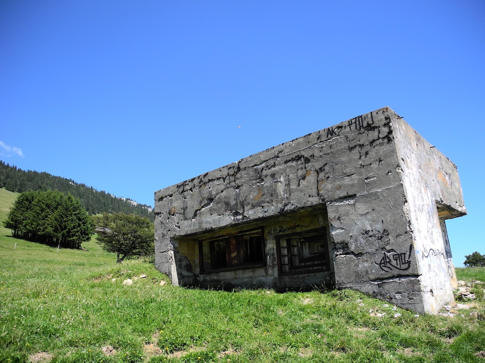
Old WW2 bunker near Aiguilles de Baulmes.
We watched the climbers for awhile, then continued to work (and slip and slide) our way down the mountain. Eventually we got onto a better forest track, and finally emerged out of the forest just east of the Col de l'Aiguillon. Down below us was a section of the Toblerone Line (the old WW2 anti-tank defences) that formed an imposing barrier across the floor of the Valley de Baumine. We passed a few other old and weathered defence installations (mainly old WW2 machine-gun bunkers), as we walked east down the valley towards Baulmes. Up to our left were the cliffs of L'Aiguillon, which now stood stark and beautiful in the afternoon sunlight.

The cliffs of L'Aiguillon.

The summit cross at the top of the cliffs of les Aiguilles de Baulmes.

On the trail near Les Prax farmhouse.

Hmm, I'm not sure. But I assume it's a warning sign for kamikaze mountain-bikers.

Last look back at les Aiguilles de Baulmes.
The route "home" was relatively easy-going. Firstly following the road that runs between the Col de l'Aiguillon and Baulmes - and passing, on either side, the Grange Neuve, La Combette, Les Prax, Les Crebillons, Les Mouilles and Les Nax farmhouses, before re-entering the forest again somewhere just below the "Les Rebans" cliffs. Somewhere in the forest off to our right was a site marked on the topographic map as "Fortification préhistorique de l'Hermitage" ... but that would just have to wait for another day.

Heading into the forest on the road below the cliffs of Les Rebans.

On the trail down through the forest.

Back at the Baumine River - where we stopped awhile to cool down.
We eventually arrived back in Baulmes at about 4.30pm - six and a half hours after we'd set out. Keener walkers can do the "Tour de Aiguille de Baulmes" in a lot less time than that, but we like to stop a lot, and take lots of photos, and take-in the views to our hearts' content .... so we're never that bothered by how long it takes us. Needless to say, we had another great Jura walk. Another ramble that I'd definitely recommend to anyone looking for a fabulous trail to follow in the magnificent Jura Mountains.

Back at the car on the outskirts of Baulmes.
Jura peaks bagged:
- Aiguilles de Baulmes (No. 24) 1559m
- Les Rebans (No. 97) 1372m
- Mont de Baulmes (No. 159) 1285m
- The top of the Aiguilles de Baulmes ridgeline is protected by a 106 hectare forest reserve, which has, at its core, an even-more-protected nature reserve. (The latter has apparently been spared from all logging activities for more than 50 years).


